You are here: Home > Network List > US - United States National Seismic Network Stations List
> Station MNTX Cornudas Mountains, Texas, USA > Earthquake Result Viewer
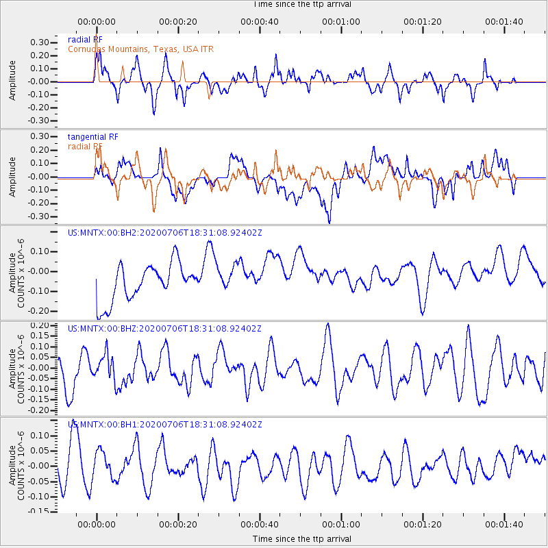
MNTX Cornudas Mountains, Texas, USA - Earthquake Result Viewer
*The percent match for this event was below the threshold and hence no stack was calculated.
| Earthquake location: |
Southeast Of Honshu, Japan |
| Earthquake latitude/longitude: |
31.5/138.2 |
| Earthquake time(UTC): |
2020/07/06 (188) 18:19:09 GMT |
| Earthquake Depth: |
381 km |
| Earthquake Magnitude: |
5.6 Mww |
| Earthquake Catalog/Contributor: |
NEIC PDE/us |
|
| Network: |
US United States National Seismic Network |
| Station: |
MNTX Cornudas Mountains, Texas, USA |
| Lat/Lon: |
31.70 N/105.38 W |
| Elevation: |
404 m |
|
| Distance: |
93.0 deg |
| Az: |
49.83 deg |
| Baz: |
310.01 deg |
| Ray Param: |
$rayparam |
*The percent match for this event was below the threshold and hence was not used in the summary stack. |
|
| Radial Match: |
60.429962 % |
| Radial Bump: |
400 |
| Transverse Match: |
43.313774 % |
| Transverse Bump: |
400 |
| SOD ConfigId: |
21709731 |
| Insert Time: |
2020-07-20 18:56:57.315 +0000 |
| GWidth: |
2.5 |
| Max Bumps: |
400 |
| Tol: |
0.001 |
|
Signal To Noise
| Channel | StoN | STA | LTA |
| US:MNTX:00:BHZ:20200706T18:31:08.92402Z | 0.65280807 | 6.364018E-8 | 9.748681E-8 |
| US:MNTX:00:BH1:20200706T18:31:08.92402Z | 0.5196497 | 4.319885E-8 | 8.3130715E-8 |
| US:MNTX:00:BH2:20200706T18:31:08.92402Z | 0.74693483 | 6.888816E-8 | 9.222781E-8 |
| Arrivals |
| Ps | |
| PpPs | |
| PsPs/PpSs | |


