You are here: Home > Network List > AV - Alaska Volcano Observatory Stations List
> Station AMKA Regional Station, Amchitka Island, Alaska > Earthquake Result Viewer
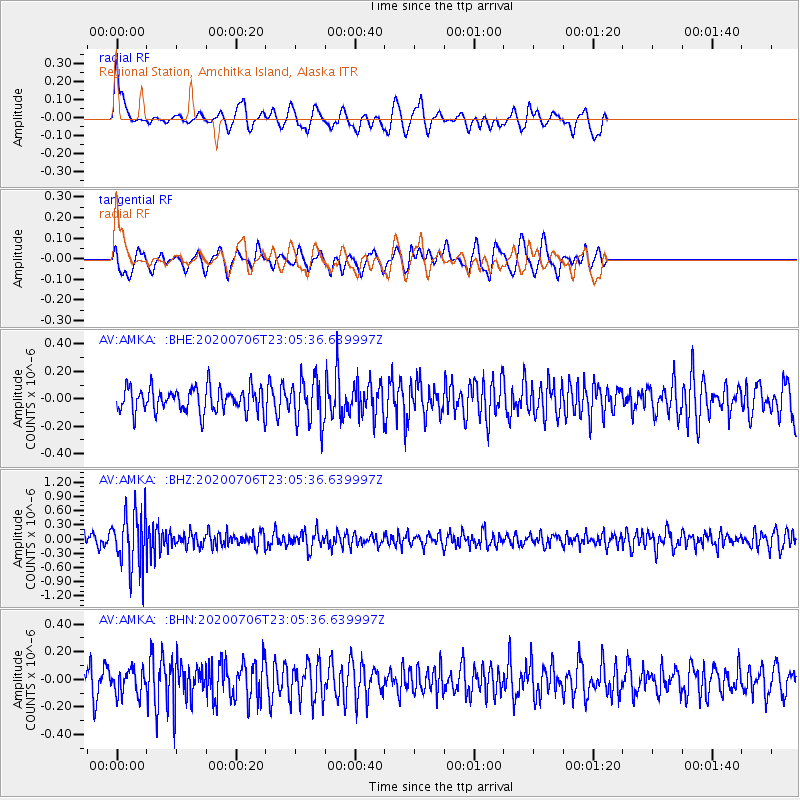
AMKA Regional Station, Amchitka Island, Alaska - Earthquake Result Viewer
*The percent match for this event was below the threshold and hence no stack was calculated.
| Earthquake location: |
Java Sea |
| Earthquake latitude/longitude: |
-5.6/110.7 |
| Earthquake time(UTC): |
2020/07/06 (188) 22:54:46 GMT |
| Earthquake Depth: |
529 km |
| Earthquake Magnitude: |
6.6 Mww |
| Earthquake Catalog/Contributor: |
NEIC PDE/us |
|
| Network: |
AV Alaska Volcano Observatory |
| Station: |
AMKA Regional Station, Amchitka Island, Alaska |
| Lat/Lon: |
51.38 N/179.30 E |
| Elevation: |
116 m |
|
| Distance: |
81.3 deg |
| Az: |
36.187 deg |
| Baz: |
249.646 deg |
| Ray Param: |
$rayparam |
*The percent match for this event was below the threshold and hence was not used in the summary stack. |
|
| Radial Match: |
57.486362 % |
| Radial Bump: |
400 |
| Transverse Match: |
49.763245 % |
| Transverse Bump: |
400 |
| SOD ConfigId: |
21709731 |
| Insert Time: |
2020-07-20 22:56:27.105 +0000 |
| GWidth: |
2.5 |
| Max Bumps: |
400 |
| Tol: |
0.001 |
|
Signal To Noise
| Channel | StoN | STA | LTA |
| AV:AMKA: :BHZ:20200706T23:05:36.639997Z | 4.8328137 | 5.863888E-7 | 1.2133486E-7 |
| AV:AMKA: :BHN:20200706T23:05:36.639997Z | 1.1296204 | 9.019304E-8 | 7.9843666E-8 |
| AV:AMKA: :BHE:20200706T23:05:36.639997Z | 1.8353182 | 1.6163794E-7 | 8.80708E-8 |
| Arrivals |
| Ps | |
| PpPs | |
| PsPs/PpSs | |


