You are here: Home > Network List > G - GEOSCOPE Stations List
> Station ATD Arta Cave - Arta, Republic of Djibouti > Earthquake Result Viewer
ATD Arta Cave - Arta, Republic of Djibouti - Earthquake Result Viewer
| Earthquake location: |
Java Sea |
| Earthquake latitude/longitude: |
-5.6/110.7 |
| Earthquake time(UTC): |
2020/07/06 (188) 22:54:46 GMT |
| Earthquake Depth: |
529 km |
| Earthquake Magnitude: |
6.6 Mww |
| Earthquake Catalog/Contributor: |
NEIC PDE/us |
|
| Network: |
G GEOSCOPE |
| Station: |
ATD Arta Cave - Arta, Republic of Djibouti |
| Lat/Lon: |
11.53 N/42.85 E |
| Elevation: |
610 m |
|
| Distance: |
69.6 deg |
| Az: |
284.442 deg |
| Baz: |
100.463 deg |
| Ray Param: |
0.053753365 |
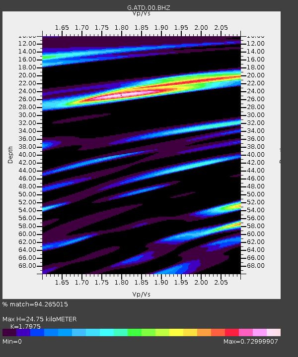
| Estimated Moho Depth: |
24.75 km |
| Estimated Crust Vp/Vs: |
1.80 |
| Assumed Crust Vp: |
6.375 km/s |
| Estimated Crust Vs: |
3.547 km/s |
| Estimated Crust Poisson's Ratio: |
0.28 |
|
| Radial Match: |
94.265015 % |
| Radial Bump: |
400 |
| Transverse Match: |
81.81533 % |
| Transverse Bump: |
400 |
| SOD ConfigId: |
21709731 |
| Insert Time: |
2020-07-20 22:57:57.339 +0000 |
| GWidth: |
2.5 |
| Max Bumps: |
400 |
| Tol: |
0.001 |
|
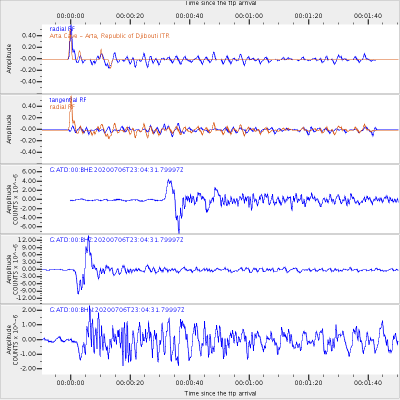
Signal To Noise
| Channel | StoN | STA | LTA |
| G:ATD:00:BHZ:20200706T23:04:31.79997Z | 50.206894 | 4.4891044E-6 | 8.941211E-8 |
| G:ATD:00:BHN:20200706T23:04:31.79997Z | 5.614084 | 5.243484E-7 | 9.339875E-8 |
| G:ATD:00:BHE:20200706T23:04:31.79997Z | 20.064371 | 2.2959182E-6 | 1.1442762E-7 |
| Arrivals |
| Ps | 3.2 SECOND |
| PpPs | 10 SECOND |
| PsPs/PpSs | 14 SECOND |


