You are here: Home > Network List > UU - University of Utah Regional Network Stations List
> Station CVRU Castle Valley Ranch, Emery, UT, USA old TA-Q16A > Earthquake Result Viewer
CVRU Castle Valley Ranch, Emery, UT, USA old TA-Q16A - Earthquake Result Viewer
| Earthquake location: |
Near Coast Of Ecuador |
| Earthquake latitude/longitude: |
-0.3/-80.5 |
| Earthquake time(UTC): |
2017/06/30 (181) 22:29:44 GMT |
| Earthquake Depth: |
7.4 km |
| Earthquake Magnitude: |
6.0 Mww |
| Earthquake Catalog/Contributor: |
NEIC PDE/us |
|
| Network: |
UU University of Utah Regional Network |
| Station: |
CVRU Castle Valley Ranch, Emery, UT, USA old TA-Q16A |
| Lat/Lon: |
38.92 N/111.17 W |
| Elevation: |
1912 m |
|
| Distance: |
48.1 deg |
| Az: |
327.706 deg |
| Baz: |
136.776 deg |
| Ray Param: |
0.069559574 |
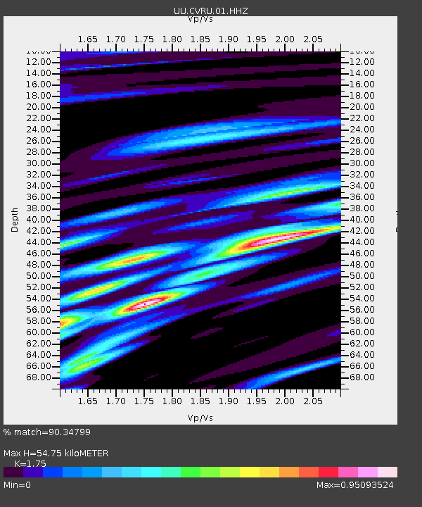
| Estimated Moho Depth: |
54.75 km |
| Estimated Crust Vp/Vs: |
1.75 |
| Assumed Crust Vp: |
6.207 km/s |
| Estimated Crust Vs: |
3.547 km/s |
| Estimated Crust Poisson's Ratio: |
0.26 |
|
| Radial Match: |
90.34799 % |
| Radial Bump: |
400 |
| Transverse Match: |
65.965454 % |
| Transverse Bump: |
400 |
| SOD ConfigId: |
2140511 |
| Insert Time: |
2017-07-14 14:27:20.541 +0000 |
| GWidth: |
2.5 |
| Max Bumps: |
400 |
| Tol: |
0.001 |
|
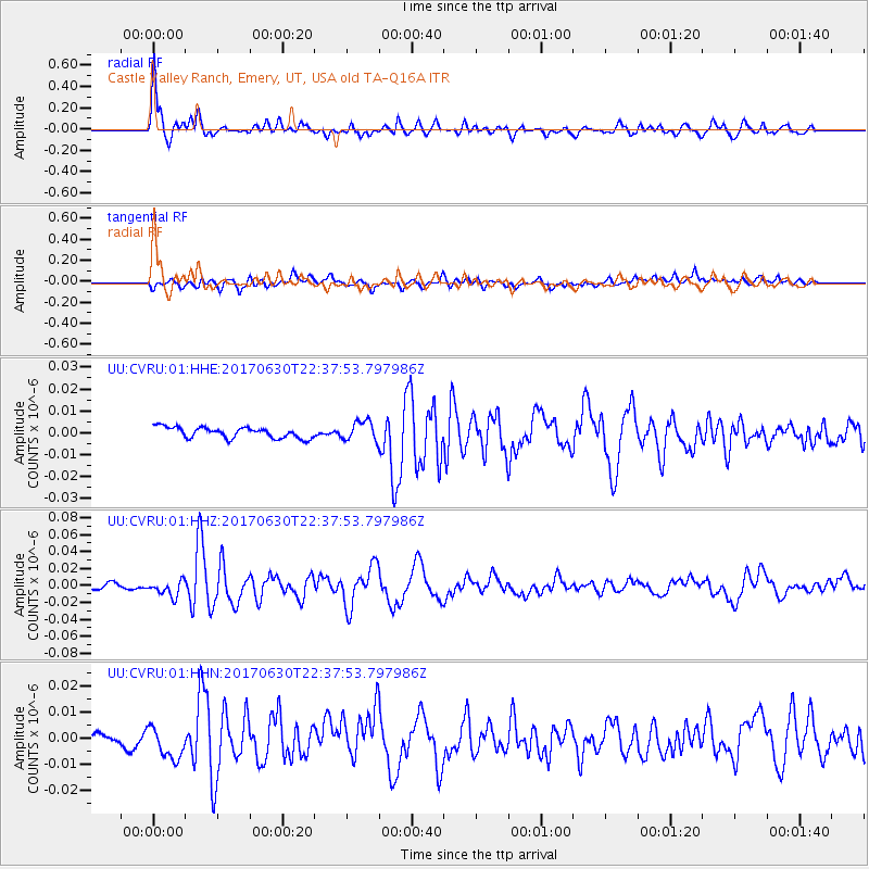
Signal To Noise
| Channel | StoN | STA | LTA |
| UU:CVRU:01:HHZ:20170630T22:37:53.797986Z | 2.9761229 | 9.146309E-9 | 3.0732297E-9 |
| UU:CVRU:01:HHN:20170630T22:37:53.797986Z | 2.0043874 | 6.2678054E-9 | 3.1270428E-9 |
| UU:CVRU:01:HHE:20170630T22:37:53.797986Z | 1.8025695 | 4.4638067E-9 | 2.4763576E-9 |
| Arrivals |
| Ps | 7.0 SECOND |
| PpPs | 23 SECOND |
| PsPs/PpSs | 30 SECOND |


