You are here: Home > Network List > UU - University of Utah Regional Network Stations List
> Station PKCU Pink Cliffs, UT, USA > Earthquake Result Viewer
PKCU Pink Cliffs, UT, USA - Earthquake Result Viewer
| Earthquake location: |
Near Coast Of Ecuador |
| Earthquake latitude/longitude: |
-0.3/-80.5 |
| Earthquake time(UTC): |
2017/06/30 (181) 22:29:44 GMT |
| Earthquake Depth: |
7.4 km |
| Earthquake Magnitude: |
6.0 Mww |
| Earthquake Catalog/Contributor: |
NEIC PDE/us |
|
| Network: |
UU University of Utah Regional Network |
| Station: |
PKCU Pink Cliffs, UT, USA |
| Lat/Lon: |
37.44 N/112.31 W |
| Elevation: |
2834 m |
|
| Distance: |
47.7 deg |
| Az: |
325.455 deg |
| Baz: |
134.566 deg |
| Ray Param: |
0.06982402 |
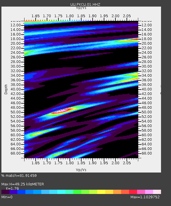
| Estimated Moho Depth: |
49.25 km |
| Estimated Crust Vp/Vs: |
1.76 |
| Assumed Crust Vp: |
6.194 km/s |
| Estimated Crust Vs: |
3.519 km/s |
| Estimated Crust Poisson's Ratio: |
0.26 |
|
| Radial Match: |
81.91459 % |
| Radial Bump: |
400 |
| Transverse Match: |
74.99069 % |
| Transverse Bump: |
400 |
| SOD ConfigId: |
2140511 |
| Insert Time: |
2017-07-14 14:27:40.826 +0000 |
| GWidth: |
2.5 |
| Max Bumps: |
400 |
| Tol: |
0.001 |
|

Signal To Noise
| Channel | StoN | STA | LTA |
| UU:PKCU:01:HHZ:20170630T22:37:50.520001Z | 7.170614 | 1.621848E-8 | 2.261798E-9 |
| UU:PKCU:01:HHN:20170630T22:37:50.520001Z | 1.2421083 | 5.4974736E-9 | 4.4259214E-9 |
| UU:PKCU:01:HHE:20170630T22:37:50.520001Z | 1.2902027 | 4.2553867E-9 | 3.2982308E-9 |
| Arrivals |
| Ps | 6.4 SECOND |
| PpPs | 21 SECOND |
| PsPs/PpSs | 27 SECOND |


