You are here: Home > Network List > JP - Japan Meteorological Agency Seismic Network Stations List
> Station JSD Sado > Earthquake Result Viewer
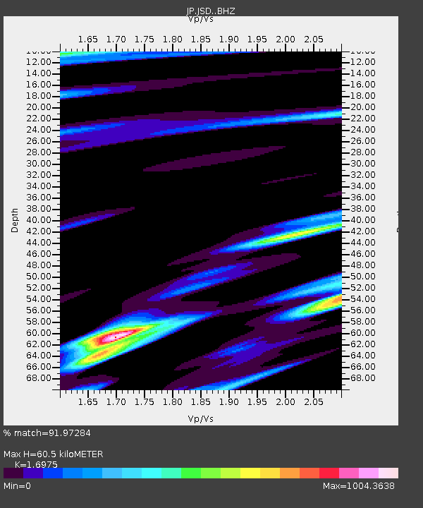
JSD Sado - Earthquake Result Viewer
| Earthquake location: |
Flores Sea |
| Earthquake latitude/longitude: |
-7.2/120.4 |
| Earthquake time(UTC): |
2020/07/14 (196) 23:33:58 GMT |
| Earthquake Depth: |
599 km |
| Earthquake Magnitude: |
5.7 Mww |
| Earthquake Catalog/Contributor: |
NEIC PDE/us |
|
| Network: |
JP Japan Meteorological Agency Seismic Network |
| Station: |
JSD Sado |
| Lat/Lon: |
38.04 N/138.26 E |
| Elevation: |
146 m |
|
| Distance: |
48.0 deg |
| Az: |
18.958 deg |
| Baz: |
204.092 deg |
| Ray Param: |
0.06673835 |
| Estimated Moho Depth: |
60.5 km |
| Estimated Crust Vp/Vs: |
1.70 |
| Assumed Crust Vp: |
6.183 km/s |
| Estimated Crust Vs: |
3.642 km/s |
| Estimated Crust Poisson's Ratio: |
0.23 |
|
| Radial Match: |
91.97284 % |
| Radial Bump: |
216 |
| Transverse Match: |
91.97717 % |
| Transverse Bump: |
228 |
| SOD ConfigId: |
21709731 |
| Insert Time: |
2020-07-28 23:37:50.055 +0000 |
| GWidth: |
2.5 |
| Max Bumps: |
400 |
| Tol: |
0.001 |
|

Signal To Noise
| Channel | StoN | STA | LTA |
| JP:JSD: :BHZ:20200714T23:41:14.299998Z | 0.94955474 | 5.8210294E-9 | 6.1302727E-9 |
| JP:JSD: :BHN:20200714T23:41:14.299998Z | 0.83387494 | 7.845343E-6 | 9.408297E-6 |
| JP:JSD: :BHE:20200714T23:41:14.299998Z | 0.8352637 | 9.095726E-6 | 1.0889647E-5 |
| Arrivals |
| Ps | 7.2 SECOND |
| PpPs | 25 SECOND |
| PsPs/PpSs | 32 SECOND |


