You are here: Home > Network List > PF - Volcanologic Network of Piton de Fournaise-OVPF Stations List
> Station CIL Cilaos (Pompiers) > Earthquake Result Viewer
CIL Cilaos (Pompiers) - Earthquake Result Viewer
| Earthquake location: |
Flores Sea |
| Earthquake latitude/longitude: |
-7.2/120.4 |
| Earthquake time(UTC): |
2020/07/14 (196) 23:33:58 GMT |
| Earthquake Depth: |
599 km |
| Earthquake Magnitude: |
5.7 Mww |
| Earthquake Catalog/Contributor: |
NEIC PDE/us |
|
| Network: |
PF Volcanologic Network of Piton de Fournaise-OVPF |
| Station: |
CIL Cilaos (Pompiers) |
| Lat/Lon: |
21.13 S/55.47 E |
| Elevation: |
1223 m |
|
| Distance: |
64.1 deg |
| Az: |
250.104 deg |
| Baz: |
87.868 deg |
| Ray Param: |
0.05687602 |
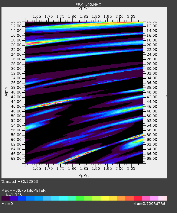
| Estimated Moho Depth: |
66.75 km |
| Estimated Crust Vp/Vs: |
1.83 |
| Assumed Crust Vp: |
4.73 km/s |
| Estimated Crust Vs: |
2.592 km/s |
| Estimated Crust Poisson's Ratio: |
0.29 |
|
| Radial Match: |
80.12853 % |
| Radial Bump: |
400 |
| Transverse Match: |
72.76317 % |
| Transverse Bump: |
400 |
| SOD ConfigId: |
21709731 |
| Insert Time: |
2020-07-28 23:38:54.872 +0000 |
| GWidth: |
2.5 |
| Max Bumps: |
400 |
| Tol: |
0.001 |
|
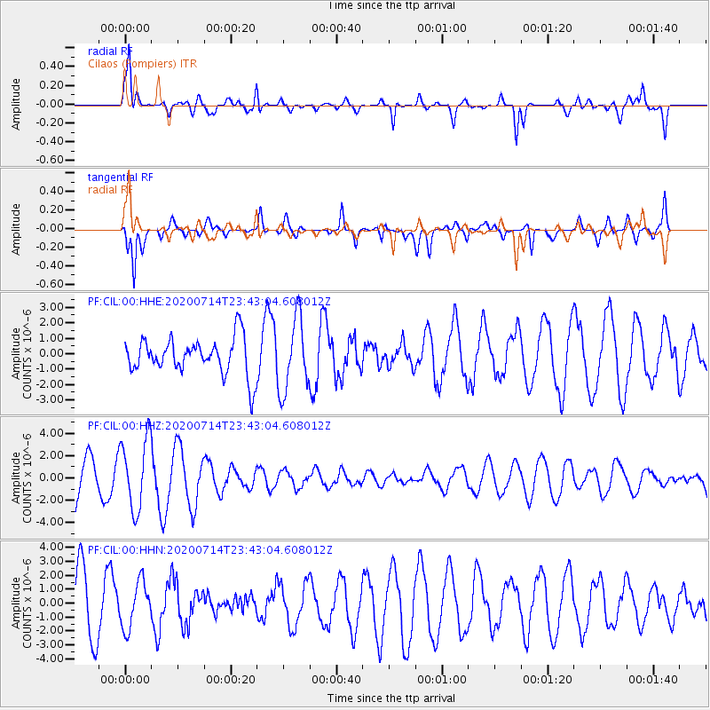
Signal To Noise
| Channel | StoN | STA | LTA |
| PF:CIL:00:HHZ:20200714T23:43:04.608012Z | 1.5718774 | 3.2083356E-6 | 2.0410853E-6 |
| PF:CIL:00:HHN:20200714T23:43:04.608012Z | 0.7043485 | 1.6768369E-6 | 2.380692E-6 |
| PF:CIL:00:HHE:20200714T23:43:04.608012Z | 2.0351489 | 2.3989312E-6 | 1.1787498E-6 |
| Arrivals |
| Ps | 12 SECOND |
| PpPs | 39 SECOND |
| PsPs/PpSs | 51 SECOND |


