You are here: Home > Network List > TA - USArray Transportable Network (new EarthScope stations) Stations List
> Station I17K Unalakleet, AK, USA > Earthquake Result Viewer
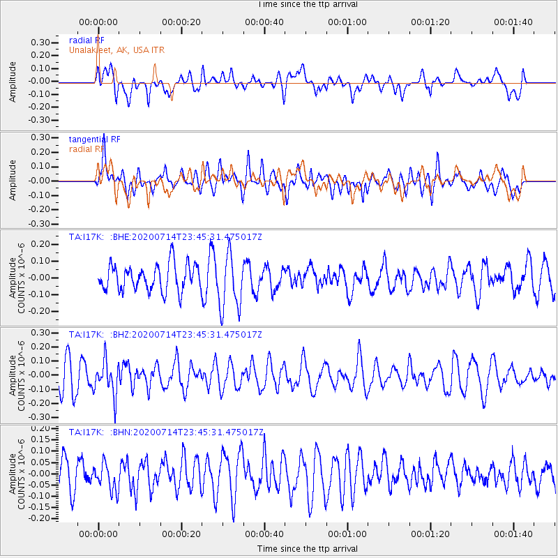
I17K Unalakleet, AK, USA - Earthquake Result Viewer
*The percent match for this event was below the threshold and hence no stack was calculated.
| Earthquake location: |
Flores Sea |
| Earthquake latitude/longitude: |
-7.2/120.4 |
| Earthquake time(UTC): |
2020/07/14 (196) 23:33:58 GMT |
| Earthquake Depth: |
599 km |
| Earthquake Magnitude: |
5.7 Mww |
| Earthquake Catalog/Contributor: |
NEIC PDE/us |
|
| Network: |
TA USArray Transportable Network (new EarthScope stations) |
| Station: |
I17K Unalakleet, AK, USA |
| Lat/Lon: |
63.89 N/160.70 W |
| Elevation: |
105 m |
|
| Distance: |
91.6 deg |
| Az: |
25.744 deg |
| Baz: |
256.851 deg |
| Ray Param: |
$rayparam |
*The percent match for this event was below the threshold and hence was not used in the summary stack. |
|
| Radial Match: |
17.78402 % |
| Radial Bump: |
400 |
| Transverse Match: |
44.95157 % |
| Transverse Bump: |
400 |
| SOD ConfigId: |
21709731 |
| Insert Time: |
2020-07-28 23:39:46.781 +0000 |
| GWidth: |
2.5 |
| Max Bumps: |
400 |
| Tol: |
0.001 |
|
Signal To Noise
| Channel | StoN | STA | LTA |
| TA:I17K: :BHZ:20200714T23:45:31.475017Z | 1.0231041 | 1.1999963E-7 | 1.1728976E-7 |
| TA:I17K: :BHN:20200714T23:45:31.475017Z | 0.7460422 | 6.09141E-8 | 8.164967E-8 |
| TA:I17K: :BHE:20200714T23:45:31.475017Z | 2.1355205 | 1.6768816E-7 | 7.8523314E-8 |
| Arrivals |
| Ps | |
| PpPs | |
| PsPs/PpSs | |


