You are here: Home > Network List > AE - Arizona Broadband Seismic Network Stations List
> Station W18A Petrified Forest, AZ, USA > Earthquake Result Viewer
W18A Petrified Forest, AZ, USA - Earthquake Result Viewer
| Earthquake location: |
Panama |
| Earthquake latitude/longitude: |
7.5/-81.9 |
| Earthquake time(UTC): |
2020/07/15 (197) 21:39:40 GMT |
| Earthquake Depth: |
5.7 km |
| Earthquake Magnitude: |
5.8 mww |
| Earthquake Catalog/Contributor: |
NEIC PDE/us |
|
| Network: |
AE Arizona Broadband Seismic Network |
| Station: |
W18A Petrified Forest, AZ, USA |
| Lat/Lon: |
35.12 N/109.74 W |
| Elevation: |
1750 m |
|
| Distance: |
37.5 deg |
| Az: |
321.111 deg |
| Baz: |
130.587 deg |
| Ray Param: |
0.076096915 |
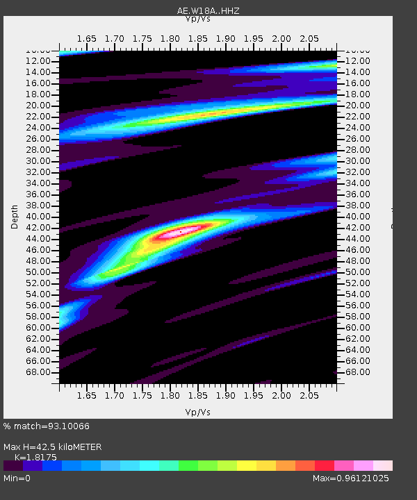
| Estimated Moho Depth: |
42.5 km |
| Estimated Crust Vp/Vs: |
1.82 |
| Assumed Crust Vp: |
6.496 km/s |
| Estimated Crust Vs: |
3.574 km/s |
| Estimated Crust Poisson's Ratio: |
0.28 |
|
| Radial Match: |
93.10066 % |
| Radial Bump: |
253 |
| Transverse Match: |
70.98461 % |
| Transverse Bump: |
352 |
| SOD ConfigId: |
21709731 |
| Insert Time: |
2020-07-29 21:40:41.321 +0000 |
| GWidth: |
2.5 |
| Max Bumps: |
400 |
| Tol: |
0.001 |
|

Signal To Noise
| Channel | StoN | STA | LTA |
| AE:W18A: :HHZ:20200715T21:46:24.639995Z | 5.9456987 | 3.3821837E-7 | 5.6884545E-8 |
| AE:W18A: :HHN:20200715T21:46:24.639995Z | 1.4297229 | 1.4744055E-7 | 1.0312526E-7 |
| AE:W18A: :HHE:20200715T21:46:24.639995Z | 3.6729064 | 1.9537009E-7 | 5.319223E-8 |
| Arrivals |
| Ps | 5.8 SECOND |
| PpPs | 17 SECOND |
| PsPs/PpSs | 23 SECOND |


