You are here: Home > Network List > CI - Caltech Regional Seismic Network Stations List
> Station LRL Laurel Mtn Radio Fac, Ridgecrest, CA, USA > Earthquake Result Viewer
LRL Laurel Mtn Radio Fac, Ridgecrest, CA, USA - Earthquake Result Viewer
| Earthquake location: |
Panama |
| Earthquake latitude/longitude: |
7.5/-81.9 |
| Earthquake time(UTC): |
2020/07/15 (197) 21:39:40 GMT |
| Earthquake Depth: |
5.7 km |
| Earthquake Magnitude: |
5.8 mww |
| Earthquake Catalog/Contributor: |
NEIC PDE/us |
|
| Network: |
CI Caltech Regional Seismic Network |
| Station: |
LRL Laurel Mtn Radio Fac, Ridgecrest, CA, USA |
| Lat/Lon: |
35.48 N/117.68 W |
| Elevation: |
1340 m |
|
| Distance: |
43.0 deg |
| Az: |
315.623 deg |
| Baz: |
121.817 deg |
| Ray Param: |
0.072846875 |
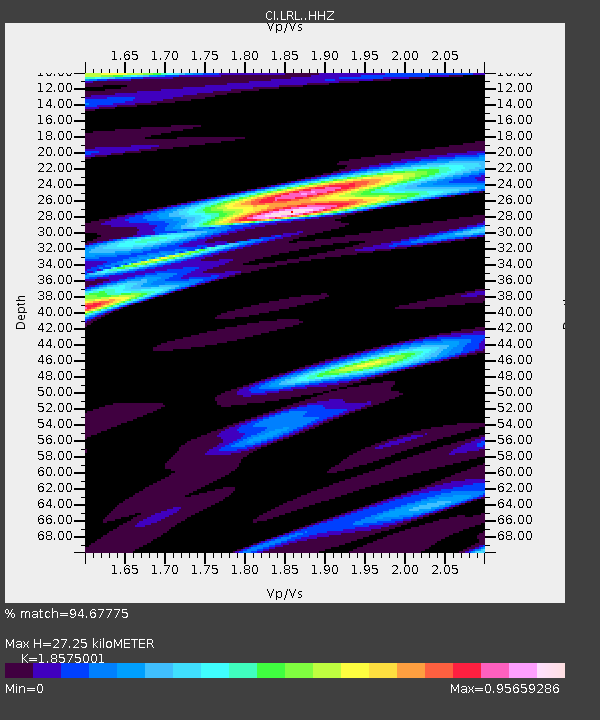
| Estimated Moho Depth: |
27.25 km |
| Estimated Crust Vp/Vs: |
1.86 |
| Assumed Crust Vp: |
6.276 km/s |
| Estimated Crust Vs: |
3.379 km/s |
| Estimated Crust Poisson's Ratio: |
0.30 |
|
| Radial Match: |
94.67775 % |
| Radial Bump: |
319 |
| Transverse Match: |
90.15701 % |
| Transverse Bump: |
392 |
| SOD ConfigId: |
21709731 |
| Insert Time: |
2020-07-29 21:48:38.081 +0000 |
| GWidth: |
2.5 |
| Max Bumps: |
400 |
| Tol: |
0.001 |
|

Signal To Noise
| Channel | StoN | STA | LTA |
| CI:LRL: :HHZ:20200715T21:47:09.837993Z | 12.811511 | 8.51868E-7 | 6.649238E-8 |
| CI:LRL: :HHN:20200715T21:47:09.837993Z | 3.4755461 | 1.8867387E-7 | 5.4286108E-8 |
| CI:LRL: :HHE:20200715T21:47:09.837993Z | 5.0715446 | 3.3979774E-7 | 6.700084E-8 |
| Arrivals |
| Ps | 4.0 SECOND |
| PpPs | 12 SECOND |
| PsPs/PpSs | 16 SECOND |


