You are here: Home > Network List > CI - Caltech Regional Seismic Network Stations List
> Station SWS Sam W. Stewart, Westmorland, CA, USA > Earthquake Result Viewer
SWS Sam W. Stewart, Westmorland, CA, USA - Earthquake Result Viewer
| Earthquake location: |
Panama |
| Earthquake latitude/longitude: |
7.5/-81.9 |
| Earthquake time(UTC): |
2020/07/15 (197) 21:39:40 GMT |
| Earthquake Depth: |
5.7 km |
| Earthquake Magnitude: |
5.8 mww |
| Earthquake Catalog/Contributor: |
NEIC PDE/us |
|
| Network: |
CI Caltech Regional Seismic Network |
| Station: |
SWS Sam W. Stewart, Westmorland, CA, USA |
| Lat/Lon: |
32.94 N/115.80 W |
| Elevation: |
140 m |
|
| Distance: |
40.3 deg |
| Az: |
313.611 deg |
| Baz: |
121.369 deg |
| Ray Param: |
0.07447023 |
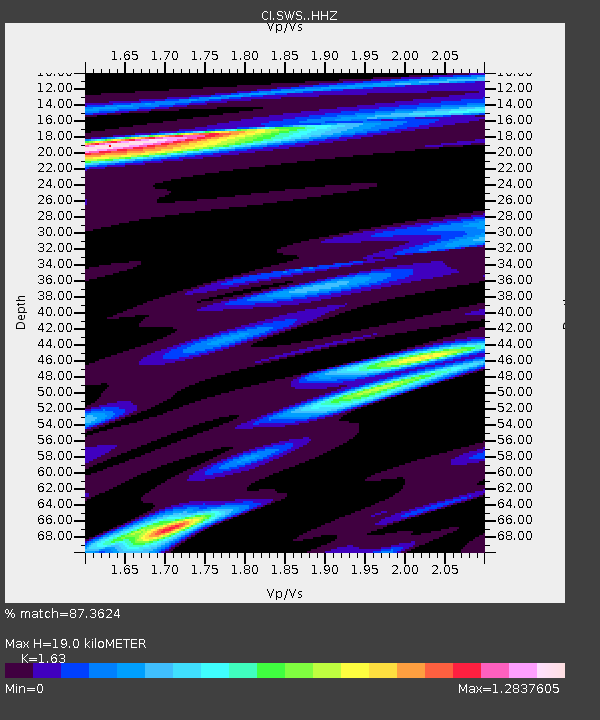
| Estimated Moho Depth: |
19.0 km |
| Estimated Crust Vp/Vs: |
1.63 |
| Assumed Crust Vp: |
6.155 km/s |
| Estimated Crust Vs: |
3.776 km/s |
| Estimated Crust Poisson's Ratio: |
0.20 |
|
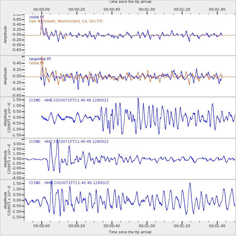
| Radial Match: |
87.3624 % |
| Radial Bump: |
400 |
| Transverse Match: |
82.92263 % |
| Transverse Bump: |
400 |
| SOD ConfigId: |
21709731 |
| Insert Time: |
2020-07-29 21:49:14.688 +0000 |
| GWidth: |
2.5 |
| Max Bumps: |
400 |
| Tol: |
0.001 |
|
Signal To Noise
| Channel | StoN | STA | LTA |
| CI:SWS: :HHZ:20200715T21:46:48.128002Z | 11.833142 | 8.963814E-7 | 7.5751764E-8 |
| CI:SWS: :HHN:20200715T21:46:48.128002Z | 2.149631 | 4.803841E-7 | 2.2347278E-7 |
| CI:SWS: :HHE:20200715T21:46:48.128002Z | 1.6524466 | 3.4202324E-7 | 2.069799E-7 |
| Arrivals |
| Ps | 2.1 SECOND |
| PpPs | 7.6 SECOND |
| PsPs/PpSs | 9.7 SECOND |


