You are here: Home > Network List > UU - University of Utah Regional Network Stations List
> Station CCUT Cedar City, UT, USA > Earthquake Result Viewer
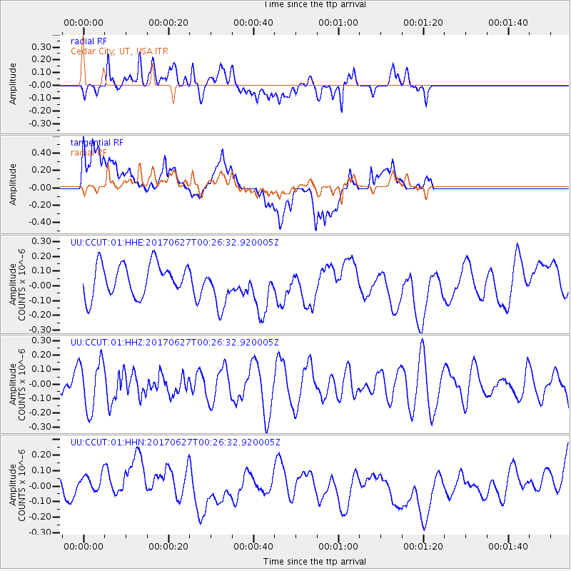
CCUT Cedar City, UT, USA - Earthquake Result Viewer
*The percent match for this event was below the threshold and hence no stack was calculated.
| Earthquake location: |
South Of Fiji Islands |
| Earthquake latitude/longitude: |
-24.8/-177.2 |
| Earthquake time(UTC): |
2017/06/27 (178) 00:14:37 GMT |
| Earthquake Depth: |
132 km |
| Earthquake Magnitude: |
5.5 Mww |
| Earthquake Catalog/Contributor: |
NEIC PDE/us |
|
| Network: |
UU University of Utah Regional Network |
| Station: |
CCUT Cedar City, UT, USA |
| Lat/Lon: |
37.55 N/113.36 W |
| Elevation: |
2127 m |
|
| Distance: |
86.3 deg |
| Az: |
45.642 deg |
| Baz: |
234.85 deg |
| Ray Param: |
$rayparam |
*The percent match for this event was below the threshold and hence was not used in the summary stack. |
|
| Radial Match: |
36.79453 % |
| Radial Bump: |
400 |
| Transverse Match: |
36.65372 % |
| Transverse Bump: |
400 |
| SOD ConfigId: |
2140511 |
| Insert Time: |
2017-07-14 22:12:00.892 +0000 |
| GWidth: |
2.5 |
| Max Bumps: |
400 |
| Tol: |
0.001 |
|
Signal To Noise
| Channel | StoN | STA | LTA |
| UU:CCUT:01:HHZ:20170627T00:26:32.920005Z | 1.6861813 | 1.7171752E-7 | 1.0183812E-7 |
| UU:CCUT:01:HHN:20170627T00:26:32.920005Z | 0.85054743 | 7.879602E-8 | 9.2641535E-8 |
| UU:CCUT:01:HHE:20170627T00:26:32.920005Z | 1.3977387 | 1.5021193E-7 | 1.0746783E-7 |
| Arrivals |
| Ps | |
| PpPs | |
| PsPs/PpSs | |


