You are here: Home > Network List > N4 - Central and EAstern US Network Stations List
> Station O48B Farmland, IN, USA > Earthquake Result Viewer
O48B Farmland, IN, USA - Earthquake Result Viewer
| Earthquake location: |
Panama |
| Earthquake latitude/longitude: |
7.5/-81.9 |
| Earthquake time(UTC): |
2020/07/15 (197) 21:39:40 GMT |
| Earthquake Depth: |
5.7 km |
| Earthquake Magnitude: |
5.8 mww |
| Earthquake Catalog/Contributor: |
NEIC PDE/us |
|
| Network: |
N4 Central and EAstern US Network |
| Station: |
O48B Farmland, IN, USA |
| Lat/Lon: |
40.26 N/85.16 W |
| Elevation: |
300 m |
|
| Distance: |
32.8 deg |
| Az: |
355.427 deg |
| Baz: |
174.07 deg |
| Ray Param: |
0.07852306 |
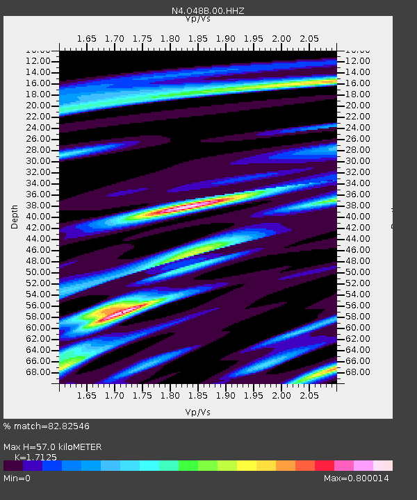
| Estimated Moho Depth: |
57.0 km |
| Estimated Crust Vp/Vs: |
1.71 |
| Assumed Crust Vp: |
6.498 km/s |
| Estimated Crust Vs: |
3.794 km/s |
| Estimated Crust Poisson's Ratio: |
0.24 |
|
| Radial Match: |
82.82546 % |
| Radial Bump: |
400 |
| Transverse Match: |
72.99419 % |
| Transverse Bump: |
400 |
| SOD ConfigId: |
21709731 |
| Insert Time: |
2020-07-29 21:56:41.865 +0000 |
| GWidth: |
2.5 |
| Max Bumps: |
400 |
| Tol: |
0.001 |
|

Signal To Noise
| Channel | StoN | STA | LTA |
| N4:O48B:00:HHZ:20200715T21:45:43.720012Z | 11.2924385 | 9.244602E-7 | 8.186542E-8 |
| N4:O48B:00:HH1:20200715T21:45:43.720012Z | 3.5125542 | 4.9539153E-7 | 1.4103456E-7 |
| N4:O48B:00:HH2:20200715T21:45:43.720012Z | 1.3932632 | 1.4360226E-7 | 1.0306901E-7 |
| Arrivals |
| Ps | 6.8 SECOND |
| PpPs | 22 SECOND |
| PsPs/PpSs | 29 SECOND |


