You are here: Home > Network List > GM - US Geological Survey Networks Stations List
> Station IWM01 Jericho 2M Well Monitoring Station > Earthquake Result Viewer
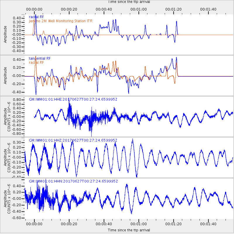
IWM01 Jericho 2M Well Monitoring Station - Earthquake Result Viewer
*The percent match for this event was below the threshold and hence no stack was calculated.
| Earthquake location: |
South Of Fiji Islands |
| Earthquake latitude/longitude: |
-24.8/-177.2 |
| Earthquake time(UTC): |
2017/06/27 (178) 00:14:37 GMT |
| Earthquake Depth: |
132 km |
| Earthquake Magnitude: |
5.5 Mww |
| Earthquake Catalog/Contributor: |
NEIC PDE/us |
|
| Network: |
GM US Geological Survey Networks |
| Station: |
IWM01 Jericho 2M Well Monitoring Station |
| Lat/Lon: |
36.73 N/96.53 W |
| Elevation: |
328 m |
|
| Distance: |
97.5 deg |
| Az: |
53.093 deg |
| Baz: |
244.771 deg |
| Ray Param: |
$rayparam |
*The percent match for this event was below the threshold and hence was not used in the summary stack. |
|
| Radial Match: |
44.50905 % |
| Radial Bump: |
400 |
| Transverse Match: |
59.967678 % |
| Transverse Bump: |
400 |
| SOD ConfigId: |
2140511 |
| Insert Time: |
2017-07-14 22:13:30.953 +0000 |
| GWidth: |
2.5 |
| Max Bumps: |
400 |
| Tol: |
0.001 |
|
Signal To Noise
| Channel | StoN | STA | LTA |
| GM:IWM01:01:HHZ:20170627T00:27:24.659995Z | 1.3507462 | 1.7702813E-7 | 1.3105951E-7 |
| GM:IWM01:01:HHN:20170627T00:27:24.659995Z | 0.97387546 | 1.9018549E-7 | 1.9528729E-7 |
| GM:IWM01:01:HHE:20170627T00:27:24.659995Z | 1.4421543 | 2.7994253E-7 | 1.9411414E-7 |
| Arrivals |
| Ps | |
| PpPs | |
| PsPs/PpSs | |


