You are here: Home > Network List > IU - Global Seismograph Network (GSN - IRIS/USGS) Stations List
> Station JOHN Johnston Island, USA > Earthquake Result Viewer
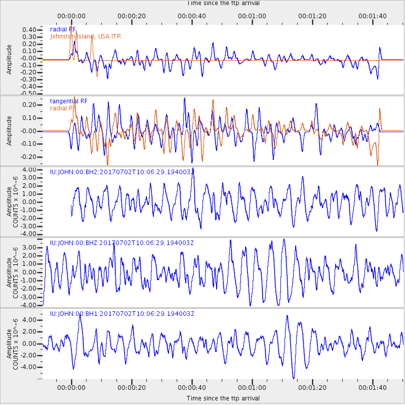
JOHN Johnston Island, USA - Earthquake Result Viewer
*The percent match for this event was below the threshold and hence no stack was calculated.
| Earthquake location: |
Kermadec Islands Region |
| Earthquake latitude/longitude: |
-27.4/-176.5 |
| Earthquake time(UTC): |
2017/07/02 (183) 09:58:50 GMT |
| Earthquake Depth: |
16 km |
| Earthquake Magnitude: |
5.7 Mww |
| Earthquake Catalog/Contributor: |
NEIC PDE/us |
|
| Network: |
IU Global Seismograph Network (GSN - IRIS/USGS) |
| Station: |
JOHN Johnston Island, USA |
| Lat/Lon: |
16.73 N/169.53 W |
| Elevation: |
2.0 m |
|
| Distance: |
44.3 deg |
| Az: |
9.511 deg |
| Baz: |
188.823 deg |
| Ray Param: |
$rayparam |
*The percent match for this event was below the threshold and hence was not used in the summary stack. |
|
| Radial Match: |
53.287697 % |
| Radial Bump: |
400 |
| Transverse Match: |
49.977234 % |
| Transverse Bump: |
400 |
| SOD ConfigId: |
2140511 |
| Insert Time: |
2017-07-16 01:54:28.769 +0000 |
| GWidth: |
2.5 |
| Max Bumps: |
400 |
| Tol: |
0.001 |
|
Signal To Noise
| Channel | StoN | STA | LTA |
| IU:JOHN:00:BHZ:20170702T10:06:29.194003Z | 0.88718545 | 1.402557E-6 | 1.5809063E-6 |
| IU:JOHN:00:BH1:20170702T10:06:29.194003Z | 2.3512607 | 2.597642E-6 | 1.1047869E-6 |
| IU:JOHN:00:BH2:20170702T10:06:29.194003Z | 1.0146087 | 1.1697728E-6 | 1.1529299E-6 |
| Arrivals |
| Ps | |
| PpPs | |
| PsPs/PpSs | |


