You are here: Home > Network List > US - United States National Seismic Network Stations List
> Station AMTX Amarillo, Texas, USA > Earthquake Result Viewer
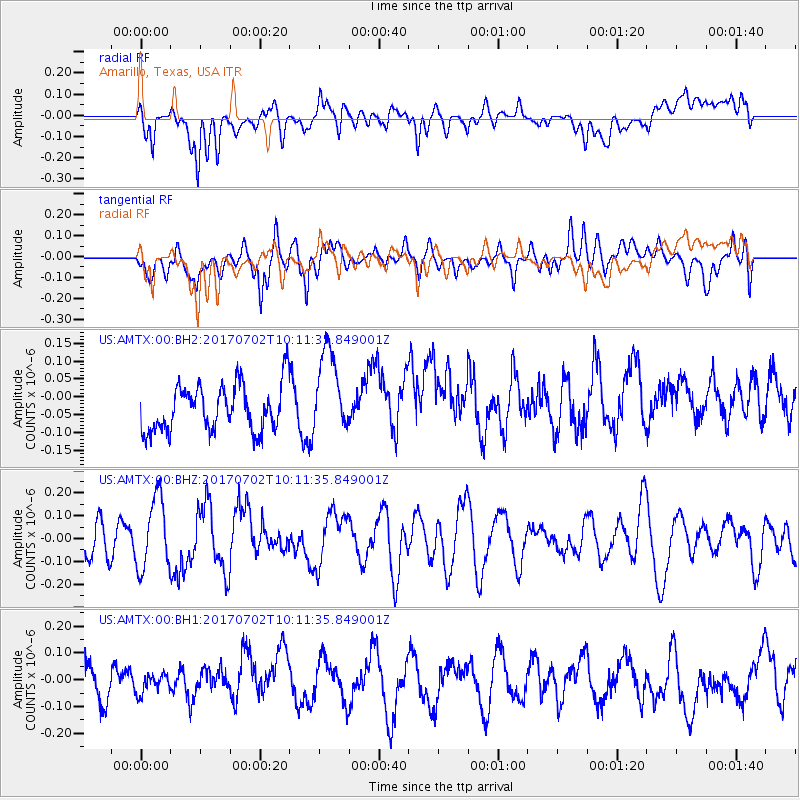
AMTX Amarillo, Texas, USA - Earthquake Result Viewer
*The percent match for this event was below the threshold and hence no stack was calculated.
| Earthquake location: |
Kermadec Islands Region |
| Earthquake latitude/longitude: |
-27.4/-176.5 |
| Earthquake time(UTC): |
2017/07/02 (183) 09:58:50 GMT |
| Earthquake Depth: |
16 km |
| Earthquake Magnitude: |
5.7 Mww |
| Earthquake Catalog/Contributor: |
NEIC PDE/us |
|
| Network: |
US United States National Seismic Network |
| Station: |
AMTX Amarillo, Texas, USA |
| Lat/Lon: |
34.53 N/101.41 W |
| Elevation: |
1010 m |
|
| Distance: |
93.9 deg |
| Az: |
53.082 deg |
| Baz: |
239.464 deg |
| Ray Param: |
$rayparam |
*The percent match for this event was below the threshold and hence was not used in the summary stack. |
|
| Radial Match: |
55.66058 % |
| Radial Bump: |
400 |
| Transverse Match: |
57.8953 % |
| Transverse Bump: |
400 |
| SOD ConfigId: |
2140511 |
| Insert Time: |
2017-07-16 01:55:46.209 +0000 |
| GWidth: |
2.5 |
| Max Bumps: |
400 |
| Tol: |
0.001 |
|
Signal To Noise
| Channel | StoN | STA | LTA |
| US:AMTX:00:BHZ:20170702T10:11:35.849001Z | 2.3902626 | 1.5603324E-7 | 6.52787E-8 |
| US:AMTX:00:BH1:20170702T10:11:35.849001Z | 0.67611104 | 4.0283275E-8 | 5.9580856E-8 |
| US:AMTX:00:BH2:20170702T10:11:35.849001Z | 1.8189993 | 1.1851927E-7 | 6.51563E-8 |
| Arrivals |
| Ps | |
| PpPs | |
| PsPs/PpSs | |


