You are here: Home > Network List > TA - USArray Transportable Network (new EarthScope stations) Stations List
> Station E20K Nigu River, AK, USA > Earthquake Result Viewer
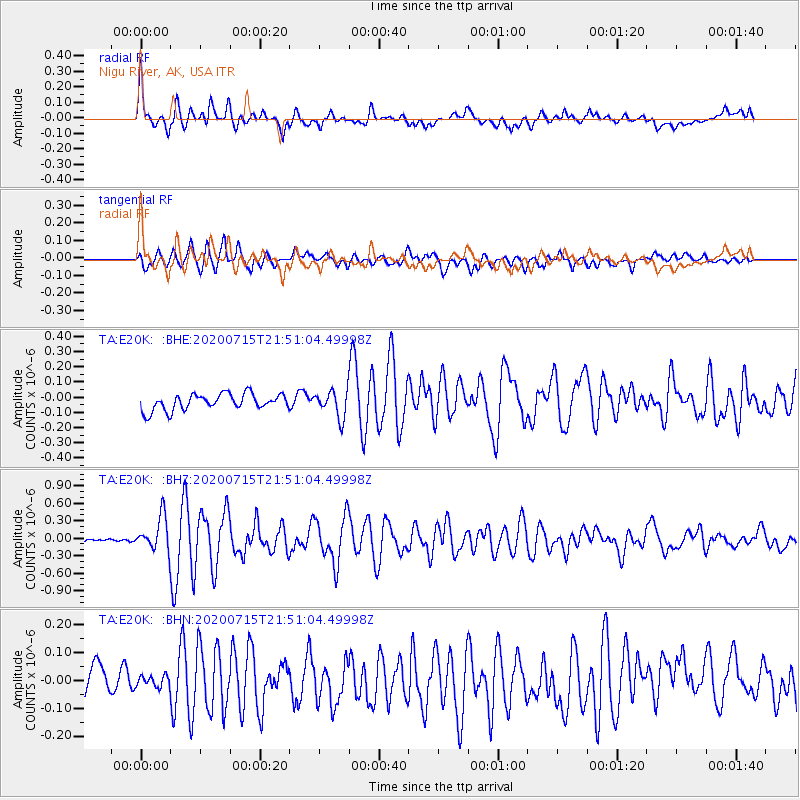
E20K Nigu River, AK, USA - Earthquake Result Viewer
| Earthquake location: |
Panama |
| Earthquake latitude/longitude: |
7.5/-81.9 |
| Earthquake time(UTC): |
2020/07/15 (197) 21:39:40 GMT |
| Earthquake Depth: |
5.7 km |
| Earthquake Magnitude: |
5.8 mww |
| Earthquake Catalog/Contributor: |
NEIC PDE/us |
|
| Network: |
TA USArray Transportable Network (new EarthScope stations) |
| Station: |
E20K Nigu River, AK, USA |
| Lat/Lon: |
68.26 N/156.19 W |
| Elevation: |
866 m |
|
| Distance: |
77.3 deg |
| Az: |
338.43 deg |
| Baz: |
101.915 deg |
| Ray Param: |
0.05043341 |
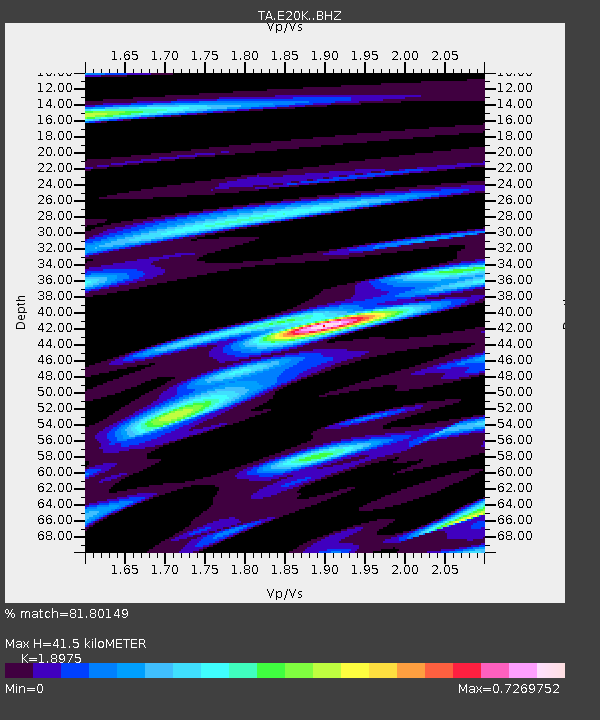
| Estimated Moho Depth: |
41.5 km |
| Estimated Crust Vp/Vs: |
1.90 |
| Assumed Crust Vp: |
6.221 km/s |
| Estimated Crust Vs: |
3.279 km/s |
| Estimated Crust Poisson's Ratio: |
0.31 |
|
| Radial Match: |
81.80149 % |
| Radial Bump: |
400 |
| Transverse Match: |
74.19441 % |
| Transverse Bump: |
400 |
| SOD ConfigId: |
21709731 |
| Insert Time: |
2020-07-29 22:04:06.797 +0000 |
| GWidth: |
2.5 |
| Max Bumps: |
400 |
| Tol: |
0.001 |
|
Signal To Noise
| Channel | StoN | STA | LTA |
| TA:E20K: :BHZ:20200715T21:51:04.49998Z | 8.084269 | 2.9796556E-7 | 3.6857454E-8 |
| TA:E20K: :BHN:20200715T21:51:04.49998Z | 0.49429518 | 2.07117E-8 | 4.1901483E-8 |
| TA:E20K: :BHE:20200715T21:51:04.49998Z | 1.6087728 | 8.680094E-8 | 5.3954757E-8 |
| Arrivals |
| Ps | 6.1 SECOND |
| PpPs | 19 SECOND |
| PsPs/PpSs | 25 SECOND |


