You are here: Home > Network List > TA - USArray Transportable Network (new EarthScope stations) Stations List
> Station F21K Alatna River, AK, USA > Earthquake Result Viewer
F21K Alatna River, AK, USA - Earthquake Result Viewer

| Earthquake location: |
Panama |
| Earthquake latitude/longitude: |
7.5/-81.9 |
| Earthquake time(UTC): |
2020/07/15 (197) 21:39:40 GMT |
| Earthquake Depth: |
5.7 km |
| Earthquake Magnitude: |
5.8 mww |
| Earthquake Catalog/Contributor: |
NEIC PDE/us |
|
| Network: |
TA USArray Transportable Network (new EarthScope stations) |
| Station: |
F21K Alatna River, AK, USA |
| Lat/Lon: |
67.22 N/153.48 W |
| Elevation: |
597 m |
|
| Distance: |
76.0 deg |
| Az: |
337.628 deg |
| Baz: |
104.232 deg |
| Ray Param: |
0.05126781 |
| Estimated Moho Depth: |
49.25 km |
| Estimated Crust Vp/Vs: |
2.05 |
| Assumed Crust Vp: |
6.455 km/s |
| Estimated Crust Vs: |
3.153 km/s |
| Estimated Crust Poisson's Ratio: |
0.34 |
|
| Radial Match: |
91.56212 % |
| Radial Bump: |
400 |
| Transverse Match: |
82.246605 % |
| Transverse Bump: |
400 |
| SOD ConfigId: |
21709731 |
| Insert Time: |
2020-07-29 22:04:26.902 +0000 |
| GWidth: |
2.5 |
| Max Bumps: |
400 |
| Tol: |
0.001 |
|
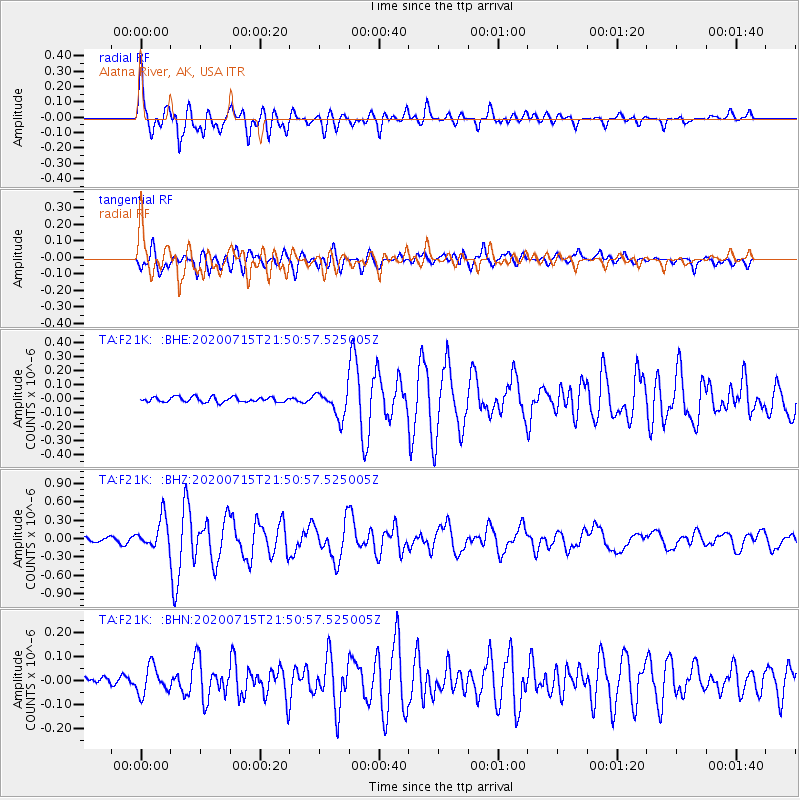
Signal To Noise
| Channel | StoN | STA | LTA |
| TA:F21K: :BHZ:20200715T21:50:57.525005Z | 7.8339796 | 2.470014E-7 | 3.1529492E-8 |
| TA:F21K: :BHN:20200715T21:50:57.525005Z | 2.2906625 | 5.739258E-8 | 2.5055012E-8 |
| TA:F21K: :BHE:20200715T21:50:57.525005Z | 5.2844257 | 9.372284E-8 | 1.773567E-8 |
| Arrivals |
| Ps | 8.2 SECOND |
| PpPs | 23 SECOND |
| PsPs/PpSs | 31 SECOND |


