You are here: Home > Network List > US - United States National Seismic Network Stations List
> Station ELK Elko, Nevada, USA > Earthquake Result Viewer
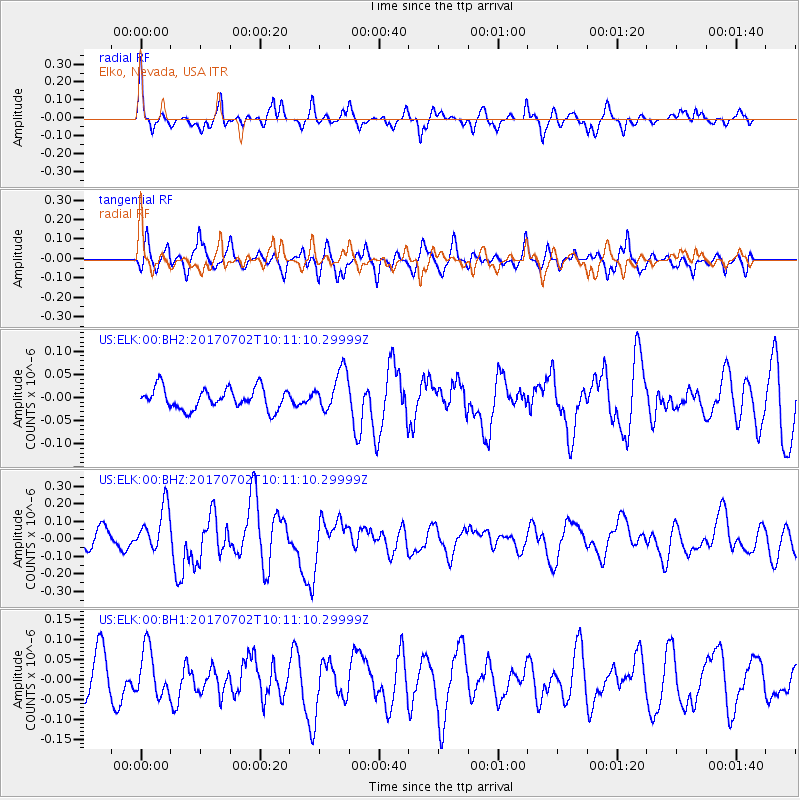
ELK Elko, Nevada, USA - Earthquake Result Viewer
*The percent match for this event was below the threshold and hence no stack was calculated.
| Earthquake location: |
Kermadec Islands Region |
| Earthquake latitude/longitude: |
-27.4/-176.5 |
| Earthquake time(UTC): |
2017/07/02 (183) 09:58:50 GMT |
| Earthquake Depth: |
16 km |
| Earthquake Magnitude: |
5.7 Mww |
| Earthquake Catalog/Contributor: |
NEIC PDE/us |
|
| Network: |
US United States National Seismic Network |
| Station: |
ELK Elko, Nevada, USA |
| Lat/Lon: |
40.74 N/115.24 W |
| Elevation: |
2210 m |
|
| Distance: |
88.4 deg |
| Az: |
41.771 deg |
| Baz: |
231.244 deg |
| Ray Param: |
$rayparam |
*The percent match for this event was below the threshold and hence was not used in the summary stack. |
|
| Radial Match: |
67.96695 % |
| Radial Bump: |
400 |
| Transverse Match: |
59.010117 % |
| Transverse Bump: |
400 |
| SOD ConfigId: |
2140511 |
| Insert Time: |
2017-07-16 01:56:00.442 +0000 |
| GWidth: |
2.5 |
| Max Bumps: |
400 |
| Tol: |
0.001 |
|
Signal To Noise
| Channel | StoN | STA | LTA |
| US:ELK:00:BHZ:20170702T10:11:10.29999Z | 2.6765287 | 1.2568965E-7 | 4.6959954E-8 |
| US:ELK:00:BH1:20170702T10:11:10.29999Z | 0.95167786 | 5.8626068E-8 | 6.160285E-8 |
| US:ELK:00:BH2:20170702T10:11:10.29999Z | 1.9346535 | 4.3934463E-8 | 2.2709216E-8 |
| Arrivals |
| Ps | |
| PpPs | |
| PsPs/PpSs | |


