You are here: Home > Network List > XD99 - Woodlark - D_Entrecasteaux Rift, PNG Stations List
> Station ECP East Cape, Main land PNG > Earthquake Result Viewer
ECP East Cape, Main land PNG - Earthquake Result Viewer
| Earthquake location: |
South Of Java, Indonesia |
| Earthquake latitude/longitude: |
-9.2/109.6 |
| Earthquake time(UTC): |
2000/01/05 (005) 18:26:07 GMT |
| Earthquake Depth: |
33 km |
| Earthquake Magnitude: |
5.5 MB, 5.5 MS, 5.8 MW, 5.7 MW |
| Earthquake Catalog/Contributor: |
WHDF/NEIC |
|
| Network: |
XD Woodlark - D_Entrecasteaux Rift, PNG |
| Station: |
ECP East Cape, Main land PNG |
| Lat/Lon: |
10.23 S/150.88 E |
| Elevation: |
97 m |
|
| Distance: |
40.7 deg |
| Az: |
94.993 deg |
| Baz: |
267.768 deg |
| Ray Param: |
0.074190736 |
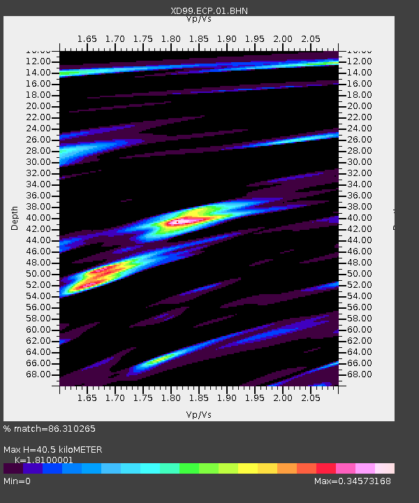
| Estimated Moho Depth: |
40.5 km |
| Estimated Crust Vp/Vs: |
1.81 |
| Assumed Crust Vp: |
4.662 km/s |
| Estimated Crust Vs: |
2.576 km/s |
| Estimated Crust Poisson's Ratio: |
0.28 |
|
| Radial Match: |
86.310265 % |
| Radial Bump: |
309 |
| Transverse Match: |
57.499966 % |
| Transverse Bump: |
400 |
| SOD ConfigId: |
16820 |
| Insert Time: |
2010-03-08 22:46:28.383 +0000 |
| GWidth: |
2.5 |
| Max Bumps: |
400 |
| Tol: |
0.001 |
|

Signal To Noise
| Channel | StoN | STA | LTA |
| XD:ECP:01:BHN:20000105T18:33:14.332012Z | 0.61746216 | 1.706337E-7 | 2.763468E-7 |
| XD:ECP:01:BHE:20000105T18:33:14.332012Z | 0.72810686 | 1.4285631E-7 | 1.962024E-7 |
| XD:ECP:01:BHZ:20000105T18:33:14.332012Z | 1.2666569 | 7.571658E-7 | 5.977671E-7 |
| Arrivals |
| Ps | 7.3 SECOND |
| PpPs | 24 SECOND |
| PsPs/PpSs | 31 SECOND |


