You are here: Home > Network List > WY - Yellowstone Wyoming Seismic Network Stations List
> Station YPP Pitchstone Plateau, YNP, WY, USA > Earthquake Result Viewer
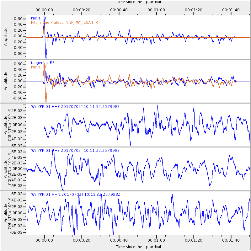
YPP Pitchstone Plateau, YNP, WY, USA - Earthquake Result Viewer
*The percent match for this event was below the threshold and hence no stack was calculated.
| Earthquake location: |
Kermadec Islands Region |
| Earthquake latitude/longitude: |
-27.4/-176.5 |
| Earthquake time(UTC): |
2017/07/02 (183) 09:58:50 GMT |
| Earthquake Depth: |
16 km |
| Earthquake Magnitude: |
5.7 Mww |
| Earthquake Catalog/Contributor: |
NEIC PDE/us |
|
| Network: |
WY Yellowstone Wyoming Seismic Network |
| Station: |
YPP Pitchstone Plateau, YNP, WY, USA |
| Lat/Lon: |
44.27 N/110.80 W |
| Elevation: |
2707 m |
|
| Distance: |
93.1 deg |
| Az: |
40.953 deg |
| Baz: |
234.242 deg |
| Ray Param: |
$rayparam |
*The percent match for this event was below the threshold and hence was not used in the summary stack. |
|
| Radial Match: |
62.55214 % |
| Radial Bump: |
400 |
| Transverse Match: |
67.05997 % |
| Transverse Bump: |
400 |
| SOD ConfigId: |
2140511 |
| Insert Time: |
2017-07-16 01:58:28.649 +0000 |
| GWidth: |
2.5 |
| Max Bumps: |
400 |
| Tol: |
0.001 |
|
Signal To Noise
| Channel | StoN | STA | LTA |
| WY:YPP:01:HHZ:20170702T10:11:32.257998Z | 2.5128922 | 2.5293736E-9 | 1.0065587E-9 |
| WY:YPP:01:HHN:20170702T10:11:32.257998Z | 1.1569347 | 2.080555E-9 | 1.798334E-9 |
| WY:YPP:01:HHE:20170702T10:11:32.257998Z | 0.36948526 | 5.915797E-10 | 1.6010915E-9 |
| Arrivals |
| Ps | |
| PpPs | |
| PsPs/PpSs | |


