You are here: Home > Network List > XD99 - Woodlark - D_Entrecasteaux Rift, PNG Stations List
> Station ECP East Cape, Main land PNG > Earthquake Result Viewer
ECP East Cape, Main land PNG - Earthquake Result Viewer
| Earthquake location: |
Southeast Of Ryukyu Islands |
| Earthquake latitude/longitude: |
29.4/131.4 |
| Earthquake time(UTC): |
2000/06/06 (158) 14:57:02 GMT |
| Earthquake Depth: |
33 km |
| Earthquake Magnitude: |
5.8 MB, 6.0 MS, 6.4 MW, 6.4 MW |
| Earthquake Catalog/Contributor: |
WHDF/NEIC |
|
| Network: |
XD Woodlark - D_Entrecasteaux Rift, PNG |
| Station: |
ECP East Cape, Main land PNG |
| Lat/Lon: |
10.23 S/150.88 E |
| Elevation: |
97 m |
|
| Distance: |
43.7 deg |
| Az: |
151.648 deg |
| Baz: |
335.109 deg |
| Ray Param: |
0.07234203 |
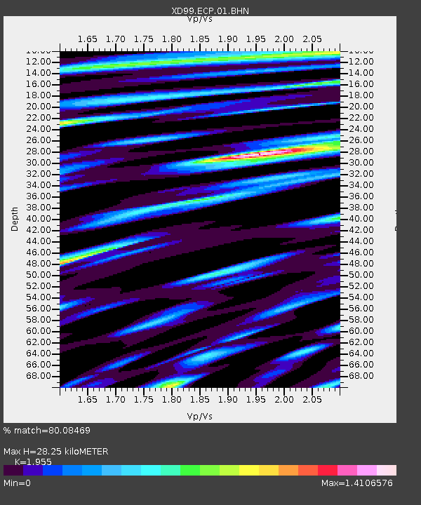
| Estimated Moho Depth: |
28.25 km |
| Estimated Crust Vp/Vs: |
1.96 |
| Assumed Crust Vp: |
4.662 km/s |
| Estimated Crust Vs: |
2.385 km/s |
| Estimated Crust Poisson's Ratio: |
0.32 |
|
| Radial Match: |
80.08469 % |
| Radial Bump: |
372 |
| Transverse Match: |
70.575584 % |
| Transverse Bump: |
400 |
| SOD ConfigId: |
3744 |
| Insert Time: |
2010-03-08 22:46:29.497 +0000 |
| GWidth: |
2.5 |
| Max Bumps: |
400 |
| Tol: |
0.001 |
|
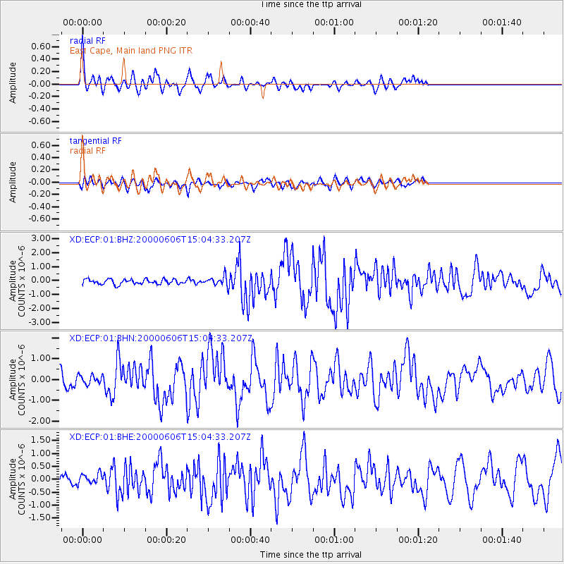
Signal To Noise
| Channel | StoN | STA | LTA |
| XD:ECP:01:BHN:20000606T15:04:33.207Z | 0.60385513 | 2.1383369E-7 | 3.541142E-7 |
| XD:ECP:01:BHE:20000606T15:04:33.207Z | 1.3685391 | 2.1011519E-7 | 1.5353247E-7 |
| XD:ECP:01:BHZ:20000606T15:04:33.207Z | 1.9947517 | 3.4634007E-7 | 1.7362565E-7 |
| Arrivals |
| Ps | 6.0 SECOND |
| PpPs | 17 SECOND |
| PsPs/PpSs | 23 SECOND |


