You are here: Home > Network List > XD99 - Woodlark - D_Entrecasteaux Rift, PNG Stations List
> Station ECP East Cape, Main land PNG > Earthquake Result Viewer
ECP East Cape, Main land PNG - Earthquake Result Viewer

| Earthquake location: |
Kermadec Islands Region |
| Earthquake latitude/longitude: |
-28.1/-176.3 |
| Earthquake time(UTC): |
2000/03/29 (089) 07:13:53 GMT |
| Earthquake Depth: |
10 km |
| Earthquake Magnitude: |
5.1 MB, 5.9 MS, 6.1 MW, 5.7 MW |
| Earthquake Catalog/Contributor: |
WHDF/NEIC |
|
| Network: |
XD Woodlark - D_Entrecasteaux Rift, PNG |
| Station: |
ECP East Cape, Main land PNG |
| Lat/Lon: |
10.23 S/150.88 E |
| Elevation: |
97 m |
|
| Distance: |
35.6 deg |
| Az: |
293.518 deg |
| Baz: |
124.639 deg |
| Ray Param: |
0.07714981 |
| Estimated Moho Depth: |
60.0 km |
| Estimated Crust Vp/Vs: |
1.83 |
| Assumed Crust Vp: |
4.662 km/s |
| Estimated Crust Vs: |
2.555 km/s |
| Estimated Crust Poisson's Ratio: |
0.29 |
|
| Radial Match: |
87.04279 % |
| Radial Bump: |
266 |
| Transverse Match: |
52.196445 % |
| Transverse Bump: |
400 |
| SOD ConfigId: |
3744 |
| Insert Time: |
2010-03-08 22:46:30.621 +0000 |
| GWidth: |
2.5 |
| Max Bumps: |
400 |
| Tol: |
0.001 |
|
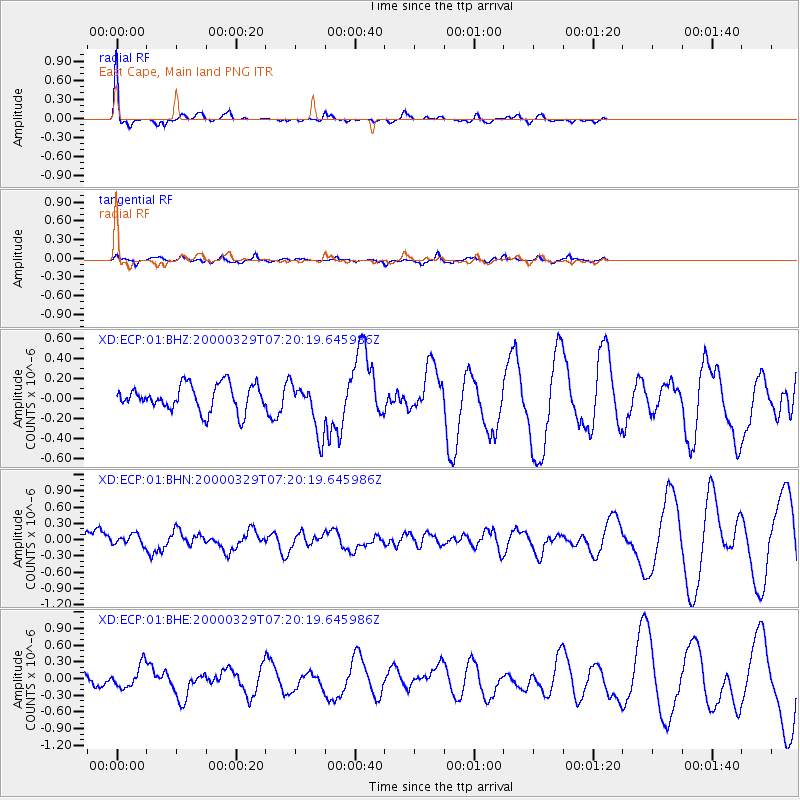
Signal To Noise
| Channel | StoN | STA | LTA |
| XD:ECP:01:BHN:20000329T07:20:19.645986Z | 0.5446113 | 9.86163E-8 | 1.8107649E-7 |
| XD:ECP:01:BHE:20000329T07:20:19.645986Z | 2.4966567 | 2.0202692E-7 | 8.091899E-8 |
| XD:ECP:01:BHZ:20000329T07:20:19.645986Z | 1.9674054 | 2.5389397E-7 | 1.2905015E-7 |
| Arrivals |
| Ps | 11 SECOND |
| PpPs | 35 SECOND |
| PsPs/PpSs | 46 SECOND |


