You are here: Home > Network List > GS - US Geological Survey Networks Stations List
> Station KAN13 Rinehart Farm > Earthquake Result Viewer
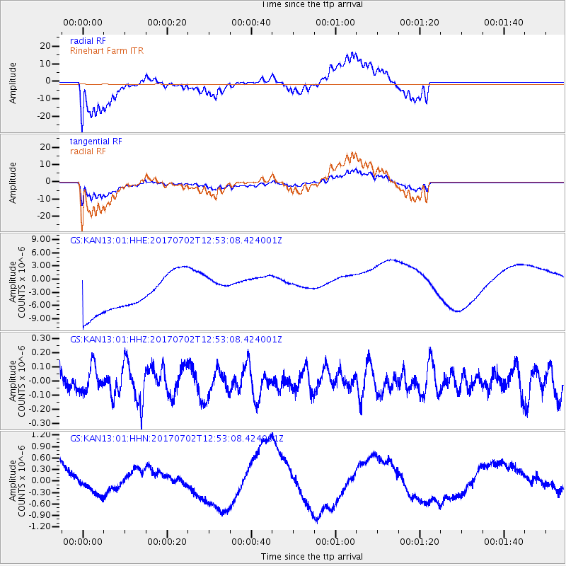
KAN13 Rinehart Farm - Earthquake Result Viewer
*The percent match for this event was below the threshold and hence no stack was calculated.
| Earthquake location: |
Kermadec Islands Region |
| Earthquake latitude/longitude: |
-27.4/-176.1 |
| Earthquake time(UTC): |
2017/07/02 (183) 12:40:05 GMT |
| Earthquake Depth: |
10 km |
| Earthquake Magnitude: |
5.5 Mww |
| Earthquake Catalog/Contributor: |
NEIC PDE/us |
|
| Network: |
GS US Geological Survey Networks |
| Station: |
KAN13 Rinehart Farm |
| Lat/Lon: |
37.01 N/97.48 W |
| Elevation: |
340 m |
|
| Distance: |
97.7 deg |
| Az: |
52.356 deg |
| Baz: |
241.553 deg |
| Ray Param: |
$rayparam |
*The percent match for this event was below the threshold and hence was not used in the summary stack. |
|
| Radial Match: |
65.2421 % |
| Radial Bump: |
400 |
| Transverse Match: |
63.792976 % |
| Transverse Bump: |
400 |
| SOD ConfigId: |
2140511 |
| Insert Time: |
2017-07-16 04:34:00.782 +0000 |
| GWidth: |
2.5 |
| Max Bumps: |
400 |
| Tol: |
0.001 |
|
Signal To Noise
| Channel | StoN | STA | LTA |
| GS:KAN13:01:HHZ:20170702T12:53:08.424001Z | 1.1650454 | 9.013495E-8 | 7.736604E-8 |
| GS:KAN13:01:HHN:20170702T12:53:08.424001Z | 0.5437696 | 1.9451288E-7 | 3.5771194E-7 |
| GS:KAN13:01:HHE:20170702T12:53:08.424001Z | 0.8543739 | 3.5284222E-6 | 4.129834E-6 |
| Arrivals |
| Ps | |
| PpPs | |
| PsPs/PpSs | |


