You are here: Home > Network List > AK - Alaska Regional Network Stations List
> Station FYU Fort Yukon, Alaska, USA > Earthquake Result Viewer
FYU Fort Yukon, Alaska, USA - Earthquake Result Viewer
| Earthquake location: |
Eastern New Guinea Reg., P.N.G. |
| Earthquake latitude/longitude: |
-7.8/147.8 |
| Earthquake time(UTC): |
2020/07/17 (199) 02:50:23 GMT |
| Earthquake Depth: |
85 km |
| Earthquake Magnitude: |
6.9 mww |
| Earthquake Catalog/Contributor: |
NEIC PDE/us |
|
| Network: |
AK Alaska Regional Network |
| Station: |
FYU Fort Yukon, Alaska, USA |
| Lat/Lon: |
66.57 N/145.23 W |
| Elevation: |
137 m |
|
| Distance: |
88.3 deg |
| Az: |
21.614 deg |
| Baz: |
245.855 deg |
| Ray Param: |
0.042550854 |
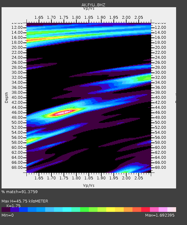
| Estimated Moho Depth: |
45.75 km |
| Estimated Crust Vp/Vs: |
1.75 |
| Assumed Crust Vp: |
6.522 km/s |
| Estimated Crust Vs: |
3.727 km/s |
| Estimated Crust Poisson's Ratio: |
0.26 |
|
| Radial Match: |
91.3759 % |
| Radial Bump: |
300 |
| Transverse Match: |
91.72716 % |
| Transverse Bump: |
392 |
| SOD ConfigId: |
21709731 |
| Insert Time: |
2020-07-31 02:52:01.464 +0000 |
| GWidth: |
2.5 |
| Max Bumps: |
400 |
| Tol: |
0.001 |
|

Signal To Noise
| Channel | StoN | STA | LTA |
| AK:FYU: :BHZ:20200717T03:02:34.028014Z | 69.00192 | 4.508144E-6 | 6.53336E-8 |
| AK:FYU: :BHN:20200717T03:02:34.028014Z | 8.837746 | 1.2892059E-6 | 1.4587496E-7 |
| AK:FYU: :BHE:20200717T03:02:34.028014Z | 8.56983 | 2.1081144E-6 | 2.4599257E-7 |
| Arrivals |
| Ps | 5.4 SECOND |
| PpPs | 19 SECOND |
| PsPs/PpSs | 24 SECOND |


