You are here: Home > Network List > AK - Alaska Regional Network Stations List
> Station GLB Gilahina Butte, AK, USA > Earthquake Result Viewer
GLB Gilahina Butte, AK, USA - Earthquake Result Viewer
| Earthquake location: |
Eastern New Guinea Reg., P.N.G. |
| Earthquake latitude/longitude: |
-7.8/147.8 |
| Earthquake time(UTC): |
2020/07/17 (199) 02:50:23 GMT |
| Earthquake Depth: |
85 km |
| Earthquake Magnitude: |
6.9 mww |
| Earthquake Catalog/Contributor: |
NEIC PDE/us |
|
| Network: |
AK Alaska Regional Network |
| Station: |
GLB Gilahina Butte, AK, USA |
| Lat/Lon: |
61.44 N/143.81 W |
| Elevation: |
855 m |
|
| Distance: |
86.8 deg |
| Az: |
26.589 deg |
| Baz: |
247.346 deg |
| Ray Param: |
0.0436267 |
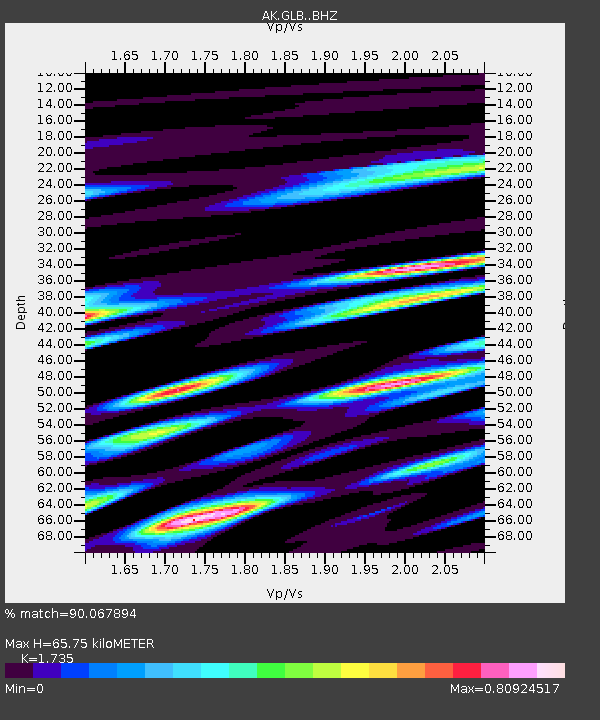
| Estimated Moho Depth: |
65.75 km |
| Estimated Crust Vp/Vs: |
1.74 |
| Assumed Crust Vp: |
6.566 km/s |
| Estimated Crust Vs: |
3.785 km/s |
| Estimated Crust Poisson's Ratio: |
0.25 |
|
| Radial Match: |
90.067894 % |
| Radial Bump: |
400 |
| Transverse Match: |
88.04621 % |
| Transverse Bump: |
400 |
| SOD ConfigId: |
21709731 |
| Insert Time: |
2020-07-31 02:52:10.219 +0000 |
| GWidth: |
2.5 |
| Max Bumps: |
400 |
| Tol: |
0.001 |
|

Signal To Noise
| Channel | StoN | STA | LTA |
| AK:GLB: :BHZ:20200717T03:02:27.007995Z | 70.92527 | 5.148982E-6 | 7.259729E-8 |
| AK:GLB: :BHN:20200717T03:02:27.007995Z | 30.441278 | 9.819141E-7 | 3.2256008E-8 |
| AK:GLB: :BHE:20200717T03:02:27.007995Z | 30.96267 | 1.7678285E-6 | 5.7095484E-8 |
| Arrivals |
| Ps | 7.5 SECOND |
| PpPs | 27 SECOND |
| PsPs/PpSs | 34 SECOND |


