You are here: Home > Network List > XD99 - Woodlark - D_Entrecasteaux Rift, PNG Stations List
> Station SEHA Sehulea (Hilltop), Normanby Island > Earthquake Result Viewer
SEHA Sehulea (Hilltop), Normanby Island - Earthquake Result Viewer
| Earthquake location: |
Fiji Islands Region |
| Earthquake latitude/longitude: |
-15.5/-177.5 |
| Earthquake time(UTC): |
2000/05/02 (123) 09:58:34 GMT |
| Earthquake Depth: |
401 km |
| Earthquake Magnitude: |
5.3 MB, 5.7 MW |
| Earthquake Catalog/Contributor: |
WHDF/NEIC |
|
| Network: |
XD Woodlark - D_Entrecasteaux Rift, PNG |
| Station: |
SEHA Sehulea (Hilltop), Normanby Island |
| Lat/Lon: |
9.96 S/151.16 E |
| Elevation: |
115 m |
|
| Distance: |
31.0 deg |
| Az: |
276.508 deg |
| Baz: |
103.551 deg |
| Ray Param: |
0.07780929 |
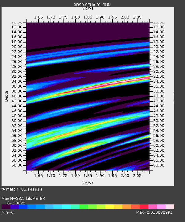
| Estimated Moho Depth: |
33.5 km |
| Estimated Crust Vp/Vs: |
2.00 |
| Assumed Crust Vp: |
4.73 km/s |
| Estimated Crust Vs: |
2.362 km/s |
| Estimated Crust Poisson's Ratio: |
0.33 |
|
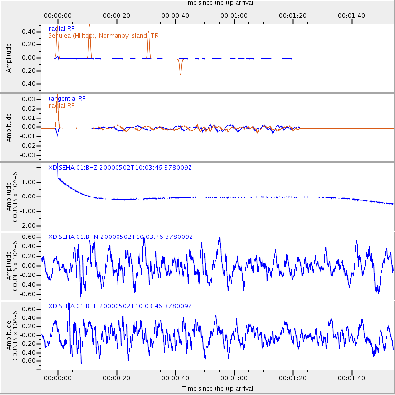
| Radial Match: |
85.141914 % |
| Radial Bump: |
200 |
| Transverse Match: |
49.94196 % |
| Transverse Bump: |
282 |
| SOD ConfigId: |
16820 |
| Insert Time: |
2010-03-08 22:46:40.121 +0000 |
| GWidth: |
2.5 |
| Max Bumps: |
400 |
| Tol: |
0.001 |
|
Signal To Noise
| Channel | StoN | STA | LTA |
| XD:SEHA:01:BHN:20000502T10:03:46.378009Z | 0.87580884 | 1.1947775E-7 | 1.3641989E-7 |
| XD:SEHA:01:BHE:20000502T10:03:46.378009Z | 1.6446583 | 2.9837412E-7 | 1.8142012E-7 |
| XD:SEHA:01:BHZ:20000502T10:03:46.378009Z | 0.6792285 | 2.9986504E-7 | 4.4147885E-7 |
| Arrivals |
| Ps | 7.4 SECOND |
| PpPs | 21 SECOND |
| PsPs/PpSs | 28 SECOND |


