You are here: Home > Network List > XD99 - Woodlark - D_Entrecasteaux Rift, PNG Stations List
> Station SEHA Sehulea (Hilltop), Normanby Island > Earthquake Result Viewer
SEHA Sehulea (Hilltop), Normanby Island - Earthquake Result Viewer
| Earthquake location: |
South Of Fiji Islands |
| Earthquake latitude/longitude: |
-24.4/179.0 |
| Earthquake time(UTC): |
2000/03/18 (078) 23:22:52 GMT |
| Earthquake Depth: |
552 km |
| Earthquake Magnitude: |
5.1 MB, 5.5 MW |
| Earthquake Catalog/Contributor: |
WHDF/NEIC |
|
| Network: |
XD Woodlark - D_Entrecasteaux Rift, PNG |
| Station: |
SEHA Sehulea (Hilltop), Normanby Island |
| Lat/Lon: |
9.96 S/151.16 E |
| Elevation: |
115 m |
|
| Distance: |
30.1 deg |
| Az: |
293.579 deg |
| Baz: |
121.953 deg |
| Ray Param: |
0.07728853 |
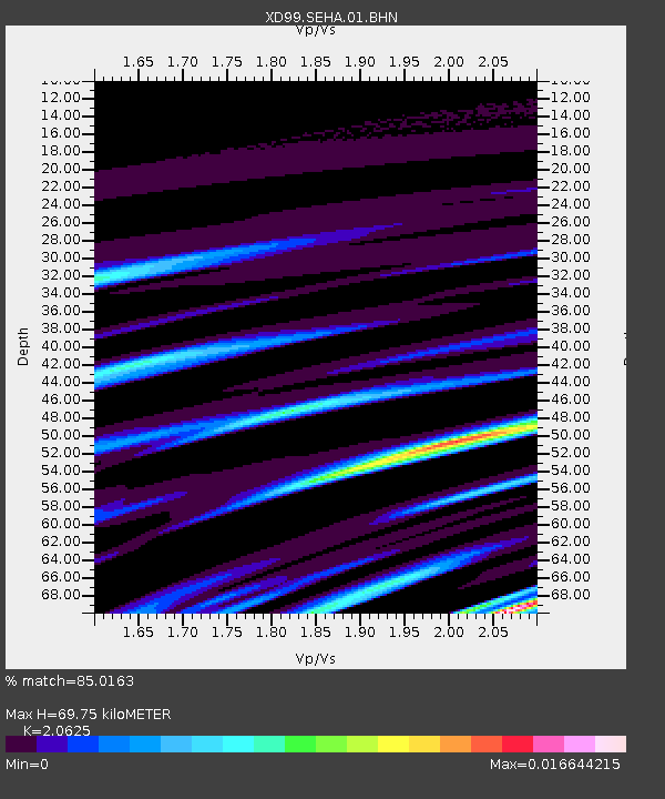
| Estimated Moho Depth: |
69.75 km |
| Estimated Crust Vp/Vs: |
2.06 |
| Assumed Crust Vp: |
4.73 km/s |
| Estimated Crust Vs: |
2.293 km/s |
| Estimated Crust Poisson's Ratio: |
0.35 |
|
| Radial Match: |
85.0163 % |
| Radial Bump: |
176 |
| Transverse Match: |
72.62429 % |
| Transverse Bump: |
262 |
| SOD ConfigId: |
16820 |
| Insert Time: |
2010-03-08 22:46:41.910 +0000 |
| GWidth: |
2.5 |
| Max Bumps: |
400 |
| Tol: |
0.001 |
|

Signal To Noise
| Channel | StoN | STA | LTA |
| XD:SEHA:01:BHN:20000318T23:27:47.676013Z | 1.4372618 | 1.4585595E-7 | 1.01481824E-7 |
| XD:SEHA:01:BHE:20000318T23:27:47.676013Z | 3.883077 | 2.7805453E-7 | 7.160675E-8 |
| XD:SEHA:01:BHZ:20000318T23:27:47.676013Z | 1.329886 | 3.862229E-7 | 2.9041806E-7 |
| Arrivals |
| Ps | 16 SECOND |
| PpPs | 44 SECOND |
| PsPs/PpSs | 60 SECOND |


