You are here: Home > Network List > XD99 - Woodlark - D_Entrecasteaux Rift, PNG Stations List
> Station SEHD Sehulea (Bwaruada Village), Normanby Island > Earthquake Result Viewer
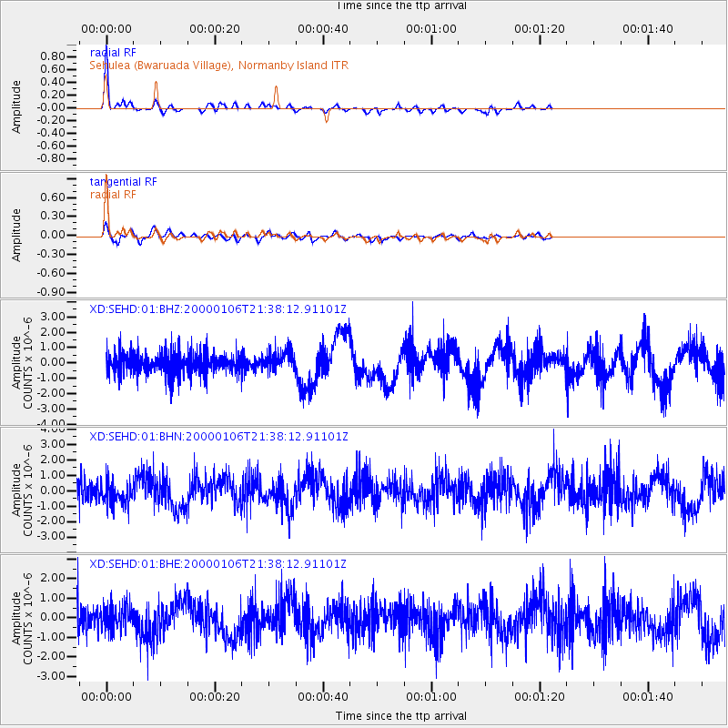
SEHD Sehulea (Bwaruada Village), Normanby Island - Earthquake Result Viewer

| Earthquake location: |
Luzon, Philippines |
| Earthquake latitude/longitude: |
16.1/119.5 |
| Earthquake time(UTC): |
2000/01/06 (006) 21:31:06 GMT |
| Earthquake Depth: |
33 km |
| Earthquake Magnitude: |
5.8 MB, 5.9 MS, 6.3 MW, 6.2 MW |
| Earthquake Catalog/Contributor: |
WHDF/NEIC |
|
| Network: |
XD Woodlark - D_Entrecasteaux Rift, PNG |
| Station: |
SEHD Sehulea (Bwaruada Village), Normanby Island |
| Lat/Lon: |
9.94 S/151.19 E |
| Elevation: |
83 m |
|
| Distance: |
40.7 deg |
| Az: |
127.397 deg |
| Baz: |
309.178 deg |
| Ray Param: |
0.074200004 |
| Estimated Moho Depth: |
42.75 km |
| Estimated Crust Vp/Vs: |
1.99 |
| Assumed Crust Vp: |
4.73 km/s |
| Estimated Crust Vs: |
2.38 km/s |
| Estimated Crust Poisson's Ratio: |
0.33 |
|
| Radial Match: |
88.04726 % |
| Radial Bump: |
400 |
| Transverse Match: |
69.09748 % |
| Transverse Bump: |
400 |
| SOD ConfigId: |
16820 |
| Insert Time: |
2010-03-08 22:46:48.100 +0000 |
| GWidth: |
2.5 |
| Max Bumps: |
400 |
| Tol: |
0.001 |
|
Signal To Noise
| Channel | StoN | STA | LTA |
| XD:SEHD:01:BHN:20000106T21:38:12.91101Z | 1.0111246 | 7.483881E-7 | 7.401542E-7 |
| XD:SEHD:01:BHE:20000106T21:38:12.91101Z | 0.976749 | 6.28155E-7 | 6.431079E-7 |
| XD:SEHD:01:BHZ:20000106T21:38:12.91101Z | 0.95573163 | 6.4116887E-7 | 6.7086705E-7 |
| Arrivals |
| Ps | 9.2 SECOND |
| PpPs | 26 SECOND |
| PsPs/PpSs | 35 SECOND |


