You are here: Home > Network List > AK - Alaska Regional Network Stations List
> Station TRF Thorofare Mountian, AK, USA > Earthquake Result Viewer
TRF Thorofare Mountian, AK, USA - Earthquake Result Viewer
| Earthquake location: |
Eastern New Guinea Reg., P.N.G. |
| Earthquake latitude/longitude: |
-7.8/147.8 |
| Earthquake time(UTC): |
2020/07/17 (199) 02:50:23 GMT |
| Earthquake Depth: |
85 km |
| Earthquake Magnitude: |
6.9 mww |
| Earthquake Catalog/Contributor: |
NEIC PDE/us |
|
| Network: |
AK Alaska Regional Network |
| Station: |
TRF Thorofare Mountian, AK, USA |
| Lat/Lon: |
63.45 N/150.29 W |
| Elevation: |
1710 m |
|
| Distance: |
84.9 deg |
| Az: |
23.464 deg |
| Baz: |
241.384 deg |
| Ray Param: |
0.044947106 |
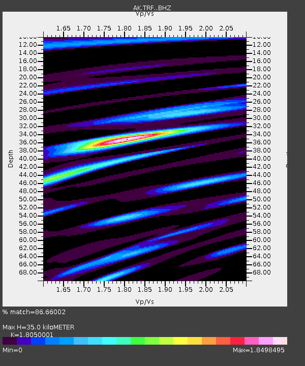
| Estimated Moho Depth: |
35.0 km |
| Estimated Crust Vp/Vs: |
1.81 |
| Assumed Crust Vp: |
6.438 km/s |
| Estimated Crust Vs: |
3.567 km/s |
| Estimated Crust Poisson's Ratio: |
0.28 |
|
| Radial Match: |
86.66002 % |
| Radial Bump: |
400 |
| Transverse Match: |
77.15467 % |
| Transverse Bump: |
400 |
| SOD ConfigId: |
21709731 |
| Insert Time: |
2020-07-31 02:53:57.223 +0000 |
| GWidth: |
2.5 |
| Max Bumps: |
400 |
| Tol: |
0.001 |
|

Signal To Noise
| Channel | StoN | STA | LTA |
| AK:TRF: :BHZ:20200717T03:02:17.947997Z | 75.653366 | 5.87095E-6 | 7.7603296E-8 |
| AK:TRF: :BHN:20200717T03:02:17.947997Z | 16.212404 | 9.602084E-7 | 5.922677E-8 |
| AK:TRF: :BHE:20200717T03:02:17.947997Z | 20.719835 | 1.7325665E-6 | 8.361874E-8 |
| Arrivals |
| Ps | 4.5 SECOND |
| PpPs | 15 SECOND |
| PsPs/PpSs | 19 SECOND |


