You are here: Home > Network List > AU - Australian Seismological Centre Stations List
> Station MOO Moorlands, Tasmania > Earthquake Result Viewer
MOO Moorlands, Tasmania - Earthquake Result Viewer
| Earthquake location: |
Eastern New Guinea Reg., P.N.G. |
| Earthquake latitude/longitude: |
-7.8/147.8 |
| Earthquake time(UTC): |
2020/07/17 (199) 02:50:23 GMT |
| Earthquake Depth: |
85 km |
| Earthquake Magnitude: |
6.9 mww |
| Earthquake Catalog/Contributor: |
NEIC PDE/us |
|
| Network: |
AU Australian Seismological Centre |
| Station: |
MOO Moorlands, Tasmania |
| Lat/Lon: |
42.44 S/147.19 E |
| Elevation: |
325 m |
|
| Distance: |
34.5 deg |
| Az: |
180.739 deg |
| Baz: |
0.988 deg |
| Ray Param: |
0.07748271 |
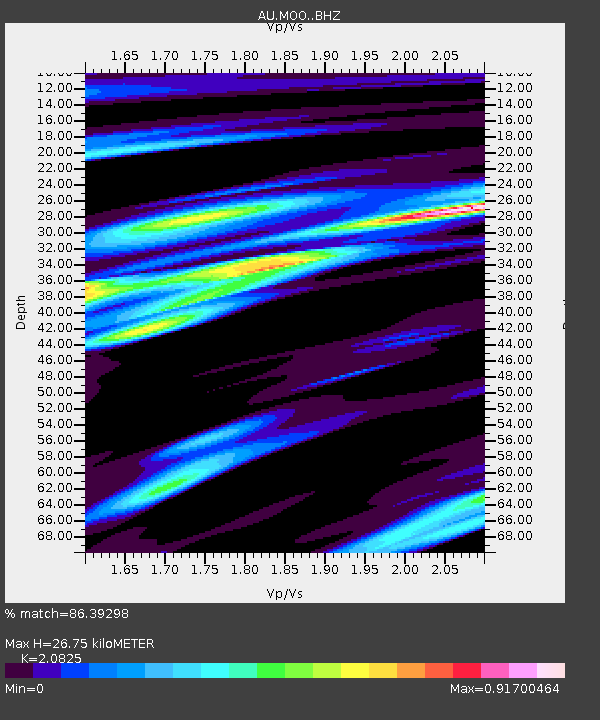
| Estimated Moho Depth: |
26.75 km |
| Estimated Crust Vp/Vs: |
2.08 |
| Assumed Crust Vp: |
6.477 km/s |
| Estimated Crust Vs: |
3.11 km/s |
| Estimated Crust Poisson's Ratio: |
0.35 |
|
| Radial Match: |
86.39298 % |
| Radial Bump: |
343 |
| Transverse Match: |
64.418465 % |
| Transverse Bump: |
400 |
| SOD ConfigId: |
21709731 |
| Insert Time: |
2020-07-31 02:54:50.258 +0000 |
| GWidth: |
2.5 |
| Max Bumps: |
400 |
| Tol: |
0.001 |
|

Signal To Noise
| Channel | StoN | STA | LTA |
| AU:MOO: :BHZ:20200717T02:56:32.644011Z | 5.186655 | 8.563584E-6 | 1.6510803E-6 |
| AU:MOO: :BHN:20200717T02:56:32.644011Z | 1.873327 | 4.339873E-6 | 2.316666E-6 |
| AU:MOO: :BHE:20200717T02:56:32.644011Z | 0.6044316 | 1.4132264E-6 | 2.338108E-6 |
| Arrivals |
| Ps | 4.8 SECOND |
| PpPs | 12 SECOND |
| PsPs/PpSs | 17 SECOND |


