You are here: Home > Network List > AV - Alaska Volcano Observatory Stations List
> Station AKRB Akutan Reef Bight, Akutan Volcano, Alaska > Earthquake Result Viewer
AKRB Akutan Reef Bight, Akutan Volcano, Alaska - Earthquake Result Viewer
| Earthquake location: |
Eastern New Guinea Reg., P.N.G. |
| Earthquake latitude/longitude: |
-7.8/147.8 |
| Earthquake time(UTC): |
2020/07/17 (199) 02:50:23 GMT |
| Earthquake Depth: |
85 km |
| Earthquake Magnitude: |
6.9 mww |
| Earthquake Catalog/Contributor: |
NEIC PDE/us |
|
| Network: |
AV Alaska Volcano Observatory |
| Station: |
AKRB Akutan Reef Bight, Akutan Volcano, Alaska |
| Lat/Lon: |
54.13 N/166.07 W |
| Elevation: |
334 m |
|
| Distance: |
72.9 deg |
| Az: |
26.376 deg |
| Baz: |
228.406 deg |
| Ray Param: |
0.05316883 |
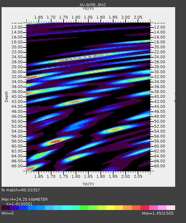
| Estimated Moho Depth: |
24.25 km |
| Estimated Crust Vp/Vs: |
1.81 |
| Assumed Crust Vp: |
5.989 km/s |
| Estimated Crust Vs: |
3.309 km/s |
| Estimated Crust Poisson's Ratio: |
0.28 |
|
| Radial Match: |
90.03357 % |
| Radial Bump: |
400 |
| Transverse Match: |
85.64215 % |
| Transverse Bump: |
400 |
| SOD ConfigId: |
21709731 |
| Insert Time: |
2020-07-31 02:55:11.999 +0000 |
| GWidth: |
2.5 |
| Max Bumps: |
400 |
| Tol: |
0.001 |
|

Signal To Noise
| Channel | StoN | STA | LTA |
| AV:AKRB: :BHZ:20200717T03:01:12.359008Z | 33.244965 | 8.080851E-6 | 2.4306993E-7 |
| AV:AKRB: :BHN:20200717T03:01:12.359008Z | 6.746669 | 2.4811338E-6 | 3.6775688E-7 |
| AV:AKRB: :BHE:20200717T03:01:12.359008Z | 10.928259 | 3.0328665E-6 | 2.7752515E-7 |
| Arrivals |
| Ps | 3.4 SECOND |
| PpPs | 11 SECOND |
| PsPs/PpSs | 14 SECOND |


