You are here: Home > Network List > AV - Alaska Volcano Observatory Stations List
> Station AKSA Akutan Strait, Akutan Volcano, Alaska > Earthquake Result Viewer
AKSA Akutan Strait, Akutan Volcano, Alaska - Earthquake Result Viewer
| Earthquake location: |
Eastern New Guinea Reg., P.N.G. |
| Earthquake latitude/longitude: |
-7.8/147.8 |
| Earthquake time(UTC): |
2020/07/17 (199) 02:50:23 GMT |
| Earthquake Depth: |
85 km |
| Earthquake Magnitude: |
6.9 mww |
| Earthquake Catalog/Contributor: |
NEIC PDE/us |
|
| Network: |
AV Alaska Volcano Observatory |
| Station: |
AKSA Akutan Strait, Akutan Volcano, Alaska |
| Lat/Lon: |
54.11 N/165.70 W |
| Elevation: |
213 m |
|
| Distance: |
73.0 deg |
| Az: |
26.543 deg |
| Baz: |
228.755 deg |
| Ray Param: |
0.05306834 |
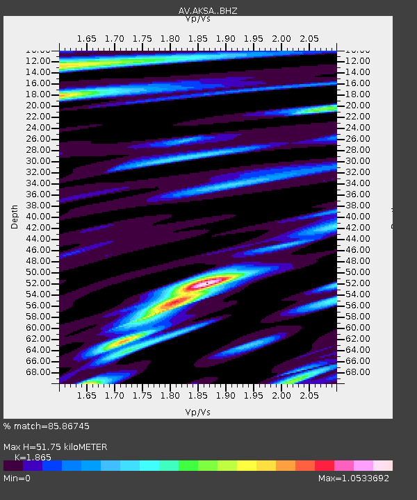
| Estimated Moho Depth: |
51.75 km |
| Estimated Crust Vp/Vs: |
1.87 |
| Assumed Crust Vp: |
5.989 km/s |
| Estimated Crust Vs: |
3.211 km/s |
| Estimated Crust Poisson's Ratio: |
0.30 |
|
| Radial Match: |
85.86745 % |
| Radial Bump: |
400 |
| Transverse Match: |
87.22241 % |
| Transverse Bump: |
400 |
| SOD ConfigId: |
21709731 |
| Insert Time: |
2020-07-31 02:55:13.956 +0000 |
| GWidth: |
2.5 |
| Max Bumps: |
400 |
| Tol: |
0.001 |
|

Signal To Noise
| Channel | StoN | STA | LTA |
| AV:AKSA: :BHZ:20200717T03:01:13.239989Z | 27.013876 | 1.2014564E-5 | 4.4475527E-7 |
| AV:AKSA: :BHN:20200717T03:01:13.239989Z | 4.4906387 | 4.5106467E-6 | 1.0044555E-6 |
| AV:AKSA: :BHE:20200717T03:01:13.239989Z | 5.007274 | 3.433283E-6 | 6.856591E-7 |
| Arrivals |
| Ps | 7.7 SECOND |
| PpPs | 24 SECOND |
| PsPs/PpSs | 32 SECOND |


