You are here: Home > Network List > AV - Alaska Volcano Observatory Stations List
> Station ETKA Kagalaska Island, Regional Station, Alaska > Earthquake Result Viewer
ETKA Kagalaska Island, Regional Station, Alaska - Earthquake Result Viewer
| Earthquake location: |
Eastern New Guinea Reg., P.N.G. |
| Earthquake latitude/longitude: |
-7.8/147.8 |
| Earthquake time(UTC): |
2020/07/17 (199) 02:50:23 GMT |
| Earthquake Depth: |
85 km |
| Earthquake Magnitude: |
6.9 mww |
| Earthquake Catalog/Contributor: |
NEIC PDE/us |
|
| Network: |
AV Alaska Volcano Observatory |
| Station: |
ETKA Kagalaska Island, Regional Station, Alaska |
| Lat/Lon: |
51.86 N/176.41 W |
| Elevation: |
290 m |
|
| Distance: |
66.9 deg |
| Az: |
23.242 deg |
| Baz: |
219.083 deg |
| Ray Param: |
0.057077873 |
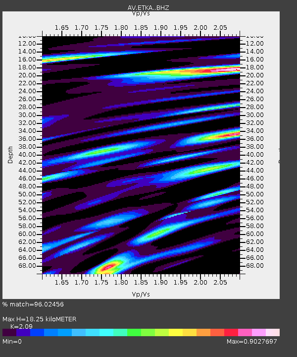
| Estimated Moho Depth: |
18.25 km |
| Estimated Crust Vp/Vs: |
2.09 |
| Assumed Crust Vp: |
5.88 km/s |
| Estimated Crust Vs: |
2.814 km/s |
| Estimated Crust Poisson's Ratio: |
0.35 |
|
| Radial Match: |
96.02456 % |
| Radial Bump: |
307 |
| Transverse Match: |
92.20774 % |
| Transverse Bump: |
347 |
| SOD ConfigId: |
21709731 |
| Insert Time: |
2020-07-31 02:55:29.520 +0000 |
| GWidth: |
2.5 |
| Max Bumps: |
400 |
| Tol: |
0.001 |
|

Signal To Noise
| Channel | StoN | STA | LTA |
| AV:ETKA: :BHZ:20200717T03:00:35.999999Z | 51.19274 | 1.0084679E-5 | 1.9699432E-7 |
| AV:ETKA: :BHN:20200717T03:00:35.999999Z | 15.118289 | 4.0084833E-6 | 2.6514135E-7 |
| AV:ETKA: :BHE:20200717T03:00:35.999999Z | 13.274172 | 3.8342782E-6 | 2.8885253E-7 |
| Arrivals |
| Ps | 3.5 SECOND |
| PpPs | 9.3 SECOND |
| PsPs/PpSs | 13 SECOND |


