You are here: Home > Network List > AV - Alaska Volcano Observatory Stations List
> Station KIMD MID Benchmark, Kanaga Volcano, Alaska > Earthquake Result Viewer
KIMD MID Benchmark, Kanaga Volcano, Alaska - Earthquake Result Viewer
| Earthquake location: |
Eastern New Guinea Reg., P.N.G. |
| Earthquake latitude/longitude: |
-7.8/147.8 |
| Earthquake time(UTC): |
2020/07/17 (199) 02:50:23 GMT |
| Earthquake Depth: |
85 km |
| Earthquake Magnitude: |
6.9 mww |
| Earthquake Catalog/Contributor: |
NEIC PDE/us |
|
| Network: |
AV Alaska Volcano Observatory |
| Station: |
KIMD MID Benchmark, Kanaga Volcano, Alaska |
| Lat/Lon: |
51.76 N/177.24 W |
| Elevation: |
183 m |
|
| Distance: |
66.5 deg |
| Az: |
22.873 deg |
| Baz: |
218.288 deg |
| Ray Param: |
0.057333313 |
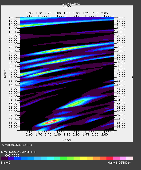
| Estimated Moho Depth: |
65.25 km |
| Estimated Crust Vp/Vs: |
1.76 |
| Assumed Crust Vp: |
5.88 km/s |
| Estimated Crust Vs: |
3.336 km/s |
| Estimated Crust Poisson's Ratio: |
0.26 |
|
| Radial Match: |
94.164314 % |
| Radial Bump: |
400 |
| Transverse Match: |
91.37728 % |
| Transverse Bump: |
400 |
| SOD ConfigId: |
21709731 |
| Insert Time: |
2020-07-31 02:56:06.626 +0000 |
| GWidth: |
2.5 |
| Max Bumps: |
400 |
| Tol: |
0.001 |
|

Signal To Noise
| Channel | StoN | STA | LTA |
| AV:KIMD: :BHZ:20200717T03:00:33.458983Z | 25.604212 | 1.1865136E-5 | 4.6340566E-7 |
| AV:KIMD: :BHN:20200717T03:00:33.458983Z | 7.789281 | 3.6130855E-6 | 4.6385352E-7 |
| AV:KIMD: :BHE:20200717T03:00:33.458983Z | 7.210723 | 2.978508E-6 | 4.1306652E-7 |
| Arrivals |
| Ps | 8.7 SECOND |
| PpPs | 30 SECOND |
| PsPs/PpSs | 38 SECOND |


