You are here: Home > Network List > AV - Alaska Volcano Observatory Stations List
> Station KOFP Flat Point, Korovin Volcano, Alaska > Earthquake Result Viewer
KOFP Flat Point, Korovin Volcano, Alaska - Earthquake Result Viewer
| Earthquake location: |
Eastern New Guinea Reg., P.N.G. |
| Earthquake latitude/longitude: |
-7.8/147.8 |
| Earthquake time(UTC): |
2020/07/17 (199) 02:50:23 GMT |
| Earthquake Depth: |
85 km |
| Earthquake Magnitude: |
6.9 mww |
| Earthquake Catalog/Contributor: |
NEIC PDE/us |
|
| Network: |
AV Alaska Volcano Observatory |
| Station: |
KOFP Flat Point, Korovin Volcano, Alaska |
| Lat/Lon: |
52.27 N/174.10 W |
| Elevation: |
662 m |
|
| Distance: |
68.2 deg |
| Az: |
24.131 deg |
| Baz: |
221.239 deg |
| Ray Param: |
0.05626376 |
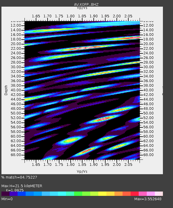
| Estimated Moho Depth: |
21.5 km |
| Estimated Crust Vp/Vs: |
1.86 |
| Assumed Crust Vp: |
5.88 km/s |
| Estimated Crust Vs: |
3.157 km/s |
| Estimated Crust Poisson's Ratio: |
0.30 |
|
| Radial Match: |
84.75227 % |
| Radial Bump: |
400 |
| Transverse Match: |
67.82926 % |
| Transverse Bump: |
400 |
| SOD ConfigId: |
21709731 |
| Insert Time: |
2020-07-31 02:56:13.148 +0000 |
| GWidth: |
2.5 |
| Max Bumps: |
400 |
| Tol: |
0.001 |
|
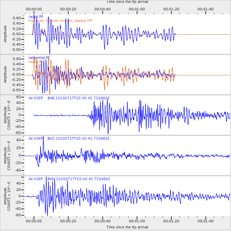
Signal To Noise
| Channel | StoN | STA | LTA |
| AV:KOFP: :BHZ:20200717T03:00:43.739989Z | 37.55767 | 1.1245918E-5 | 2.9943067E-7 |
| AV:KOFP: :BHN:20200717T03:00:43.739989Z | 11.343351 | 9.8902365E-6 | 8.718972E-7 |
| AV:KOFP: :BHE:20200717T03:00:43.739989Z | 10.992239 | 8.765606E-6 | 7.97436E-7 |
| Arrivals |
| Ps | 3.3 SECOND |
| PpPs | 10 SECOND |
| PsPs/PpSs | 13 SECOND |


