You are here: Home > Network List > AV - Alaska Volcano Observatory Stations List
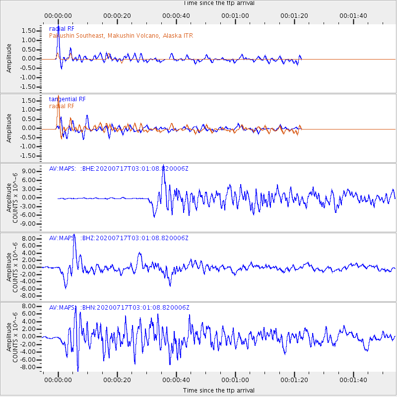
> Station MAPS Pakushin Southeast, Makushin Volcano, Alaska > Earthquake Result Viewer
MAPS Pakushin Southeast, Makushin Volcano, Alaska - Earthquake Result Viewer
| Earthquake location: |
Eastern New Guinea Reg., P.N.G. |
| Earthquake latitude/longitude: |
-7.8/147.8 |
| Earthquake time(UTC): |
2020/07/17 (199) 02:50:23 GMT |
| Earthquake Depth: |
85 km |
| Earthquake Magnitude: |
6.9 mww |
| Earthquake Catalog/Contributor: |
NEIC PDE/us |
|
| Network: |
AV Alaska Volcano Observatory |
| Station: |
MAPS Pakushin Southeast, Makushin Volcano, Alaska |
| Lat/Lon: |
53.81 N/166.94 W |
| Elevation: |
333 m |
|
| Distance: |
72.3 deg |
| Az: |
26.266 deg |
| Baz: |
227.671 deg |
| Ray Param: |
0.053566214 |
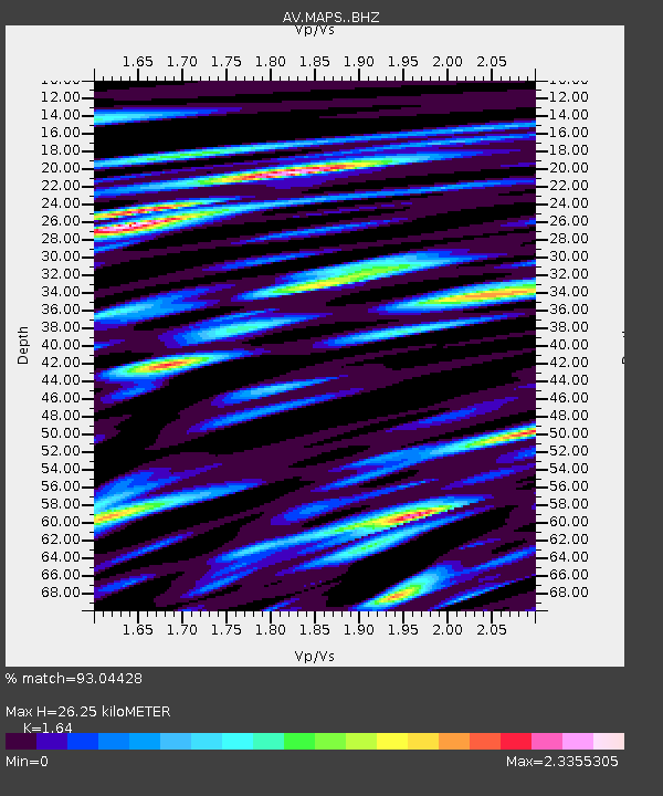
| Estimated Moho Depth: |
26.25 km |
| Estimated Crust Vp/Vs: |
1.64 |
| Assumed Crust Vp: |
3.943 km/s |
| Estimated Crust Vs: |
2.405 km/s |
| Estimated Crust Poisson's Ratio: |
0.20 |
|
| Radial Match: |
93.04428 % |
| Radial Bump: |
400 |
| Transverse Match: |
80.49082 % |
| Transverse Bump: |
400 |
| SOD ConfigId: |
21709731 |
| Insert Time: |
2020-07-31 02:56:24.693 +0000 |
| GWidth: |
2.5 |
| Max Bumps: |
400 |
| Tol: |
0.001 |
|
Signal To Noise
| Channel | StoN | STA | LTA |
| AV:MAPS: :BHZ:20200717T03:01:08.820006Z | 19.077404 | 2.377864E-6 | 1.2464297E-7 |
| AV:MAPS: :BHN:20200717T03:01:08.820006Z | 15.47559 | 2.082816E-6 | 1.3458718E-7 |
| AV:MAPS: :BHE:20200717T03:01:08.820006Z | 21.533485 | 2.6617736E-6 | 1.236109E-7 |
| Arrivals |
| Ps | 4.3 SECOND |
| PpPs | 17 SECOND |
| PsPs/PpSs | 22 SECOND |


