You are here: Home > Network List > AV - Alaska Volcano Observatory Stations List
> Station TASE Southeast, Tanaga Volcano, Alaska > Earthquake Result Viewer
TASE Southeast, Tanaga Volcano, Alaska - Earthquake Result Viewer
| Earthquake location: |
Eastern New Guinea Reg., P.N.G. |
| Earthquake latitude/longitude: |
-7.8/147.8 |
| Earthquake time(UTC): |
2020/07/17 (199) 02:50:23 GMT |
| Earthquake Depth: |
85 km |
| Earthquake Magnitude: |
6.9 mww |
| Earthquake Catalog/Contributor: |
NEIC PDE/us |
|
| Network: |
AV Alaska Volcano Observatory |
| Station: |
TASE Southeast, Tanaga Volcano, Alaska |
| Lat/Lon: |
51.83 N/178.04 W |
| Elevation: |
682 m |
|
| Distance: |
66.3 deg |
| Az: |
22.395 deg |
| Baz: |
217.468 deg |
| Ray Param: |
0.057498798 |
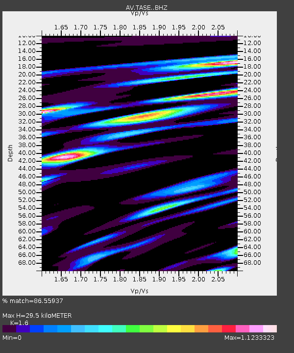
| Estimated Moho Depth: |
29.5 km |
| Estimated Crust Vp/Vs: |
1.60 |
| Assumed Crust Vp: |
6.048 km/s |
| Estimated Crust Vs: |
3.78 km/s |
| Estimated Crust Poisson's Ratio: |
0.18 |
|
| Radial Match: |
86.55937 % |
| Radial Bump: |
400 |
| Transverse Match: |
85.58278 % |
| Transverse Bump: |
400 |
| SOD ConfigId: |
21709731 |
| Insert Time: |
2020-07-31 02:57:11.739 +0000 |
| GWidth: |
2.5 |
| Max Bumps: |
400 |
| Tol: |
0.001 |
|

Signal To Noise
| Channel | StoN | STA | LTA |
| AV:TASE: :BHZ:20200717T03:00:31.880004Z | 24.439535 | 1.1114171E-5 | 4.5476196E-7 |
| AV:TASE: :BHN:20200717T03:00:31.880004Z | 6.6497197 | 4.4848807E-6 | 6.744466E-7 |
| AV:TASE: :BHE:20200717T03:00:31.880004Z | 6.6779537 | 4.581679E-6 | 6.8609023E-7 |
| Arrivals |
| Ps | 3.0 SECOND |
| PpPs | 12 SECOND |
| PsPs/PpSs | 15 SECOND |


