You are here: Home > Network List > AV - Alaska Volcano Observatory Stations List
> Station TASO South, Tanaga Volcano, Alaska > Earthquake Result Viewer
TASO South, Tanaga Volcano, Alaska - Earthquake Result Viewer
| Earthquake location: |
Eastern New Guinea Reg., P.N.G. |
| Earthquake latitude/longitude: |
-7.8/147.8 |
| Earthquake time(UTC): |
2020/07/17 (199) 02:50:23 GMT |
| Earthquake Depth: |
85 km |
| Earthquake Magnitude: |
6.9 mww |
| Earthquake Catalog/Contributor: |
NEIC PDE/us |
|
| Network: |
AV Alaska Volcano Observatory |
| Station: |
TASO South, Tanaga Volcano, Alaska |
| Lat/Lon: |
51.85 N/178.15 W |
| Elevation: |
690 m |
|
| Distance: |
66.3 deg |
| Az: |
22.324 deg |
| Baz: |
217.356 deg |
| Ray Param: |
0.057514805 |
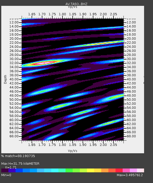
| Estimated Moho Depth: |
31.75 km |
| Estimated Crust Vp/Vs: |
1.71 |
| Assumed Crust Vp: |
6.048 km/s |
| Estimated Crust Vs: |
3.537 km/s |
| Estimated Crust Poisson's Ratio: |
0.24 |
|
| Radial Match: |
88.190735 % |
| Radial Bump: |
400 |
| Transverse Match: |
90.45598 % |
| Transverse Bump: |
400 |
| SOD ConfigId: |
21709731 |
| Insert Time: |
2020-07-31 02:57:14.068 +0000 |
| GWidth: |
2.5 |
| Max Bumps: |
400 |
| Tol: |
0.001 |
|

Signal To Noise
| Channel | StoN | STA | LTA |
| AV:TASO: :BHZ:20200717T03:00:31.718993Z | 14.102815 | 1.1847273E-5 | 8.400644E-7 |
| AV:TASO: :BHN:20200717T03:00:31.718993Z | 3.0688558 | 6.1211094E-6 | 1.99459E-6 |
| AV:TASO: :BHE:20200717T03:00:31.718993Z | 2.6944096 | 4.5336556E-6 | 1.6826156E-6 |
| Arrivals |
| Ps | 3.9 SECOND |
| PpPs | 14 SECOND |
| PsPs/PpSs | 18 SECOND |


