You are here: Home > Network List > AV - Alaska Volcano Observatory Stations List
> Station P19K Oil Pt, AK, USA > Earthquake Result Viewer
P19K Oil Pt, AK, USA - Earthquake Result Viewer
| Earthquake location: |
Eastern New Guinea Reg., P.N.G. |
| Earthquake latitude/longitude: |
-7.8/147.8 |
| Earthquake time(UTC): |
2020/07/17 (199) 02:50:23 GMT |
| Earthquake Depth: |
85 km |
| Earthquake Magnitude: |
6.9 mww |
| Earthquake Catalog/Contributor: |
NEIC PDE/us |
|
| Network: |
AV Alaska Volcano Observatory |
| Station: |
P19K Oil Pt, AK, USA |
| Lat/Lon: |
59.65 N/153.23 W |
| Elevation: |
629 m |
|
| Distance: |
81.8 deg |
| Az: |
26.089 deg |
| Baz: |
239.102 deg |
| Ray Param: |
0.047131274 |
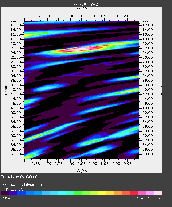
| Estimated Moho Depth: |
22.5 km |
| Estimated Crust Vp/Vs: |
1.85 |
| Assumed Crust Vp: |
5.989 km/s |
| Estimated Crust Vs: |
3.242 km/s |
| Estimated Crust Poisson's Ratio: |
0.29 |
|
| Radial Match: |
86.33338 % |
| Radial Bump: |
400 |
| Transverse Match: |
84.793846 % |
| Transverse Bump: |
400 |
| SOD ConfigId: |
21709731 |
| Insert Time: |
2020-07-31 02:57:21.236 +0000 |
| GWidth: |
2.5 |
| Max Bumps: |
400 |
| Tol: |
0.001 |
|

Signal To Noise
| Channel | StoN | STA | LTA |
| AV:P19K: :BHZ:20200717T03:02:02.025023Z | 83.717415 | 1.0237525E-5 | 1.2228669E-7 |
| AV:P19K: :BHN:20200717T03:02:02.025023Z | 28.370344 | 3.1221045E-6 | 1.1004817E-7 |
| AV:P19K: :BHE:20200717T03:02:02.025023Z | 22.835135 | 2.965575E-6 | 1.2986897E-7 |
| Arrivals |
| Ps | 3.3 SECOND |
| PpPs | 10 SECOND |
| PsPs/PpSs | 14 SECOND |


