You are here: Home > Network List > CN - Canadian National Seismograph Network Stations List
> Station WPB Watts Point, BC, CA > Earthquake Result Viewer
WPB Watts Point, BC, CA - Earthquake Result Viewer
| Earthquake location: |
Eastern New Guinea Reg., P.N.G. |
| Earthquake latitude/longitude: |
-7.8/147.8 |
| Earthquake time(UTC): |
2020/07/17 (199) 02:50:23 GMT |
| Earthquake Depth: |
85 km |
| Earthquake Magnitude: |
6.9 mww |
| Earthquake Catalog/Contributor: |
NEIC PDE/us |
|
| Network: |
CN Canadian National Seismograph Network |
| Station: |
WPB Watts Point, BC, CA |
| Lat/Lon: |
49.65 N/123.21 W |
| Elevation: |
260 m |
|
| Distance: |
95.3 deg |
| Az: |
40.745 deg |
| Baz: |
264.188 deg |
| Ray Param: |
0.04077341 |
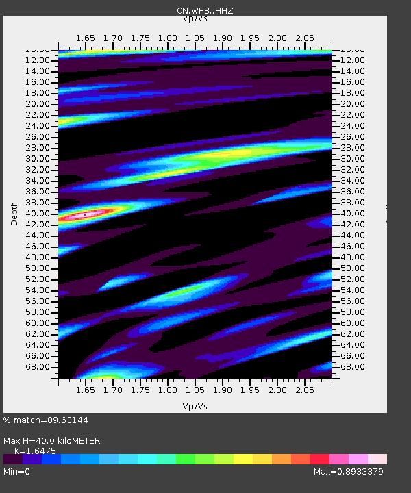
| Estimated Moho Depth: |
40.0 km |
| Estimated Crust Vp/Vs: |
1.65 |
| Assumed Crust Vp: |
6.566 km/s |
| Estimated Crust Vs: |
3.986 km/s |
| Estimated Crust Poisson's Ratio: |
0.21 |
|
| Radial Match: |
89.63144 % |
| Radial Bump: |
400 |
| Transverse Match: |
81.31277 % |
| Transverse Bump: |
400 |
| SOD ConfigId: |
21709731 |
| Insert Time: |
2020-07-31 03:00:58.003 +0000 |
| GWidth: |
2.5 |
| Max Bumps: |
400 |
| Tol: |
0.001 |
|

Signal To Noise
| Channel | StoN | STA | LTA |
| CN:WPB: :HHZ:20200717T03:03:06.440001Z | 20.977558 | 1.912418E-6 | 9.116495E-8 |
| CN:WPB: :HHN:20200717T03:03:06.440001Z | 1.2261064 | 1.9360397E-7 | 1.5790143E-7 |
| CN:WPB: :HHE:20200717T03:03:06.440001Z | 6.584262 | 6.085888E-7 | 9.2430824E-8 |
| Arrivals |
| Ps | 4.0 SECOND |
| PpPs | 16 SECOND |
| PsPs/PpSs | 20 SECOND |


