You are here: Home > Network List > TA - USArray Transportable Network (new EarthScope stations) Stations List
> Station C16K Lisburne Hills, AK, USA > Earthquake Result Viewer
C16K Lisburne Hills, AK, USA - Earthquake Result Viewer
| Earthquake location: |
Eastern New Guinea Reg., P.N.G. |
| Earthquake latitude/longitude: |
-7.8/147.8 |
| Earthquake time(UTC): |
2020/07/17 (199) 02:50:23 GMT |
| Earthquake Depth: |
85 km |
| Earthquake Magnitude: |
6.9 mww |
| Earthquake Catalog/Contributor: |
NEIC PDE/us |
|
| Network: |
TA USArray Transportable Network (new EarthScope stations) |
| Station: |
C16K Lisburne Hills, AK, USA |
| Lat/Lon: |
68.27 N/165.34 W |
| Elevation: |
102 m |
|
| Distance: |
82.8 deg |
| Az: |
15.905 deg |
| Baz: |
226.824 deg |
| Ray Param: |
0.04649487 |
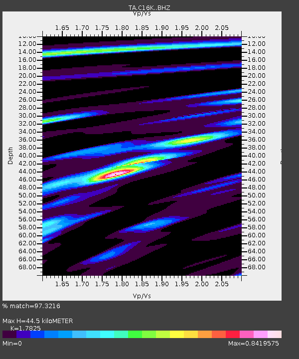
| Estimated Moho Depth: |
44.5 km |
| Estimated Crust Vp/Vs: |
1.78 |
| Assumed Crust Vp: |
5.906 km/s |
| Estimated Crust Vs: |
3.314 km/s |
| Estimated Crust Poisson's Ratio: |
0.27 |
|
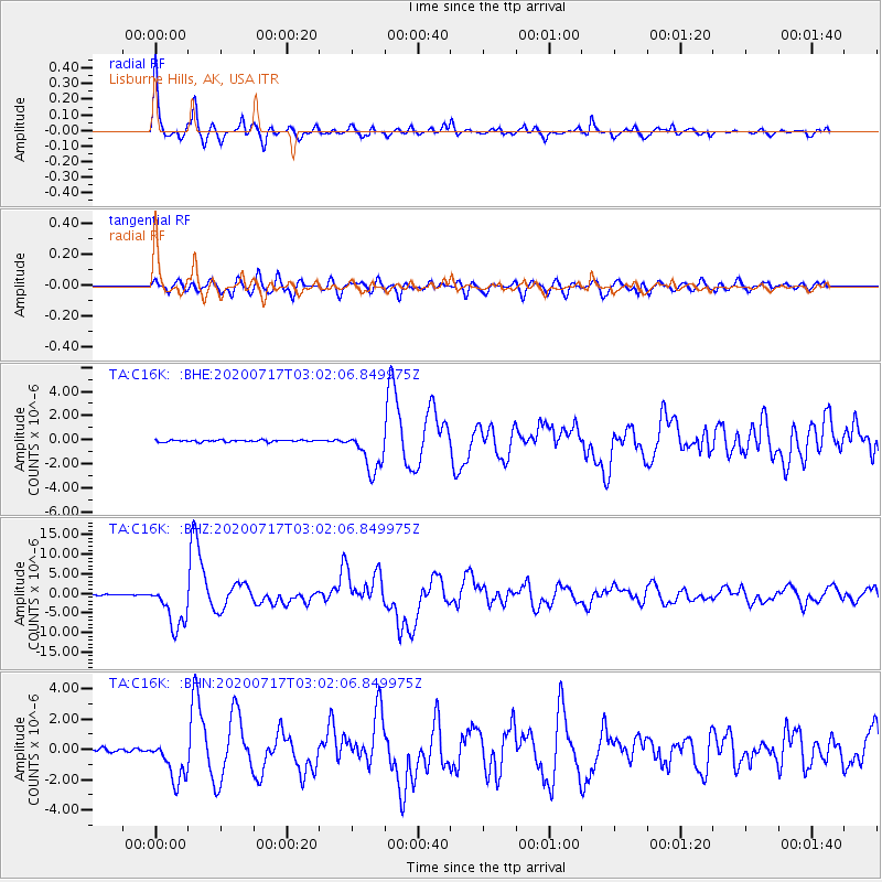
| Radial Match: |
97.3216 % |
| Radial Bump: |
372 |
| Transverse Match: |
90.00431 % |
| Transverse Bump: |
400 |
| SOD ConfigId: |
21709731 |
| Insert Time: |
2020-07-31 03:05:59.105 +0000 |
| GWidth: |
2.5 |
| Max Bumps: |
400 |
| Tol: |
0.001 |
|
Signal To Noise
| Channel | StoN | STA | LTA |
| TA:C16K: :BHZ:20200717T03:02:06.849975Z | 54.52613 | 5.7568764E-6 | 1.0558014E-7 |
| TA:C16K: :BHN:20200717T03:02:06.849975Z | 12.202689 | 1.3865641E-6 | 1.1362775E-7 |
| TA:C16K: :BHE:20200717T03:02:06.849975Z | 22.472097 | 1.7379052E-6 | 7.733614E-8 |
| Arrivals |
| Ps | 6.0 SECOND |
| PpPs | 21 SECOND |
| PsPs/PpSs | 27 SECOND |


