You are here: Home > Network List > TA - USArray Transportable Network (new EarthScope stations) Stations List
> Station D20K Etivluk River, AK, USA > Earthquake Result Viewer
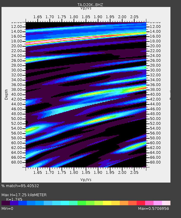
D20K Etivluk River, AK, USA - Earthquake Result Viewer
| Earthquake location: |
Eastern New Guinea Reg., P.N.G. |
| Earthquake latitude/longitude: |
-7.8/147.8 |
| Earthquake time(UTC): |
2020/07/17 (199) 02:50:23 GMT |
| Earthquake Depth: |
85 km |
| Earthquake Magnitude: |
6.9 mww |
| Earthquake Catalog/Contributor: |
NEIC PDE/us |
|
| Network: |
TA USArray Transportable Network (new EarthScope stations) |
| Station: |
D20K Etivluk River, AK, USA |
| Lat/Lon: |
68.71 N/156.61 W |
| Elevation: |
577 m |
|
| Distance: |
85.5 deg |
| Az: |
17.598 deg |
| Baz: |
235.115 deg |
| Ray Param: |
0.044525772 |
| Estimated Moho Depth: |
17.25 km |
| Estimated Crust Vp/Vs: |
1.75 |
| Assumed Crust Vp: |
6.221 km/s |
| Estimated Crust Vs: |
3.565 km/s |
| Estimated Crust Poisson's Ratio: |
0.26 |
|
| Radial Match: |
95.40532 % |
| Radial Bump: |
400 |
| Transverse Match: |
85.82253 % |
| Transverse Bump: |
400 |
| SOD ConfigId: |
21709731 |
| Insert Time: |
2020-07-31 03:06:13.918 +0000 |
| GWidth: |
2.5 |
| Max Bumps: |
400 |
| Tol: |
0.001 |
|

Signal To Noise
| Channel | StoN | STA | LTA |
| TA:D20K: :BHZ:20200717T03:02:20.849975Z | 85.36643 | 5.2610253E-6 | 6.162874E-8 |
| TA:D20K: :BHN:20200717T03:02:20.849975Z | 16.91098 | 7.3622715E-7 | 4.353545E-8 |
| TA:D20K: :BHE:20200717T03:02:20.849975Z | 36.658077 | 1.440411E-6 | 3.929314E-8 |
| Arrivals |
| Ps | 2.1 SECOND |
| PpPs | 7.4 SECOND |
| PsPs/PpSs | 9.6 SECOND |


