You are here: Home > Network List > TA - USArray Transportable Network (new EarthScope stations) Stations List
> Station E29M Blow River, YT, CAN > Earthquake Result Viewer
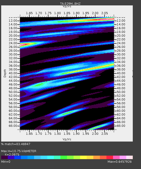
E29M Blow River, YT, CAN - Earthquake Result Viewer
| Earthquake location: |
Eastern New Guinea Reg., P.N.G. |
| Earthquake latitude/longitude: |
-7.8/147.8 |
| Earthquake time(UTC): |
2020/07/17 (199) 02:50:23 GMT |
| Earthquake Depth: |
85 km |
| Earthquake Magnitude: |
6.9 mww |
| Earthquake Catalog/Contributor: |
NEIC PDE/us |
|
| Network: |
TA USArray Transportable Network (new EarthScope stations) |
| Station: |
E29M Blow River, YT, CAN |
| Lat/Lon: |
68.39 N/137.90 W |
| Elevation: |
324 m |
|
| Distance: |
91.5 deg |
| Az: |
20.906 deg |
| Baz: |
252.625 deg |
| Ray Param: |
0.041563183 |
| Estimated Moho Depth: |
10.75 km |
| Estimated Crust Vp/Vs: |
2.10 |
| Assumed Crust Vp: |
5.981 km/s |
| Estimated Crust Vs: |
2.852 km/s |
| Estimated Crust Poisson's Ratio: |
0.35 |
|
| Radial Match: |
83.46947 % |
| Radial Bump: |
400 |
| Transverse Match: |
78.26932 % |
| Transverse Bump: |
400 |
| SOD ConfigId: |
21709731 |
| Insert Time: |
2020-07-31 03:06:39.171 +0000 |
| GWidth: |
2.5 |
| Max Bumps: |
400 |
| Tol: |
0.001 |
|

Signal To Noise
| Channel | StoN | STA | LTA |
| TA:E29M: :BHZ:20200717T03:02:49.299987Z | 48.308887 | 2.7042627E-6 | 5.5978575E-8 |
| TA:E29M: :BHN:20200717T03:02:49.299987Z | 7.568872 | 2.849507E-7 | 3.764771E-8 |
| TA:E29M: :BHE:20200717T03:02:49.299987Z | 13.415741 | 6.5450024E-7 | 4.878599E-8 |
| Arrivals |
| Ps | 2.0 SECOND |
| PpPs | 5.5 SECOND |
| PsPs/PpSs | 7.5 SECOND |


