You are here: Home > Network List > TA - USArray Transportable Network (new EarthScope stations) Stations List
> Station G21K Allakaket, AK, USA > Earthquake Result Viewer
G21K Allakaket, AK, USA - Earthquake Result Viewer

| Earthquake location: |
Eastern New Guinea Reg., P.N.G. |
| Earthquake latitude/longitude: |
-7.8/147.8 |
| Earthquake time(UTC): |
2020/07/17 (199) 02:50:23 GMT |
| Earthquake Depth: |
85 km |
| Earthquake Magnitude: |
6.9 mww |
| Earthquake Catalog/Contributor: |
NEIC PDE/us |
|
| Network: |
TA USArray Transportable Network (new EarthScope stations) |
| Station: |
G21K Allakaket, AK, USA |
| Lat/Lon: |
66.52 N/153.51 W |
| Elevation: |
446 m |
|
| Distance: |
85.3 deg |
| Az: |
20.104 deg |
| Baz: |
238.186 deg |
| Ray Param: |
0.044684142 |
| Estimated Moho Depth: |
47.5 km |
| Estimated Crust Vp/Vs: |
1.60 |
| Assumed Crust Vp: |
6.455 km/s |
| Estimated Crust Vs: |
4.035 km/s |
| Estimated Crust Poisson's Ratio: |
0.18 |
|
| Radial Match: |
90.880745 % |
| Radial Bump: |
400 |
| Transverse Match: |
88.67265 % |
| Transverse Bump: |
400 |
| SOD ConfigId: |
21709731 |
| Insert Time: |
2020-07-31 03:07:08.795 +0000 |
| GWidth: |
2.5 |
| Max Bumps: |
400 |
| Tol: |
0.001 |
|
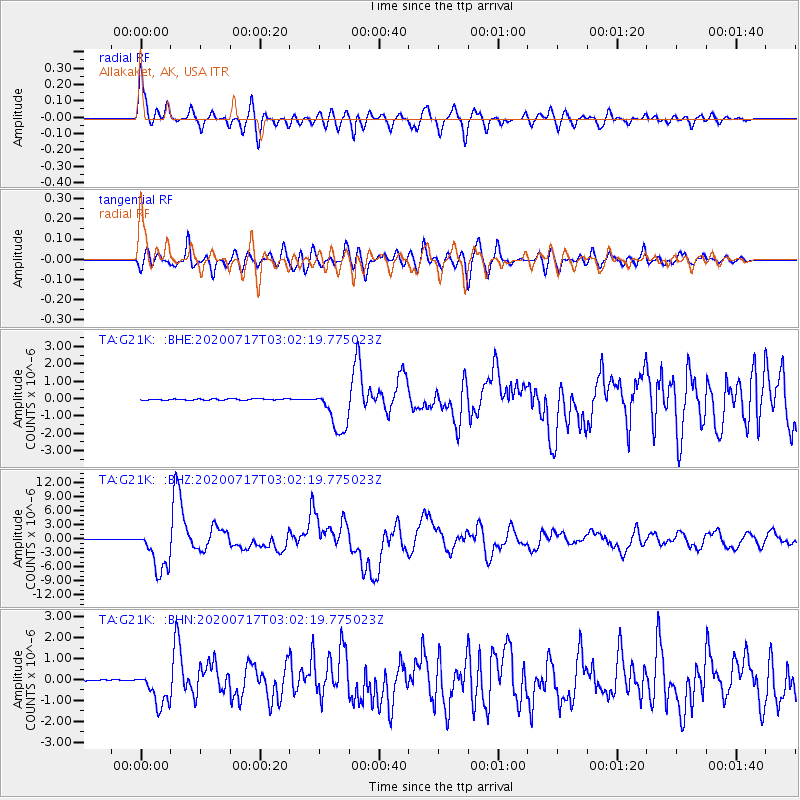
Signal To Noise
| Channel | StoN | STA | LTA |
| TA:G21K: :BHZ:20200717T03:02:19.775023Z | 86.23638 | 4.7213766E-6 | 5.474924E-8 |
| TA:G21K: :BHN:20200717T03:02:19.775023Z | 14.548895 | 8.417882E-7 | 5.7859253E-8 |
| TA:G21K: :BHE:20200717T03:02:19.775023Z | 33.155083 | 1.2714503E-6 | 3.8348578E-8 |
| Arrivals |
| Ps | 4.5 SECOND |
| PpPs | 19 SECOND |
| PsPs/PpSs | 23 SECOND |


