You are here: Home > Network List > TA - USArray Transportable Network (new EarthScope stations) Stations List
> Station I28M Miner Creek, YT, CAN > Earthquake Result Viewer
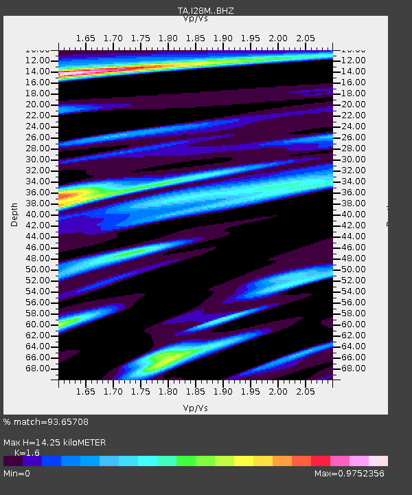
I28M Miner Creek, YT, CAN - Earthquake Result Viewer
| Earthquake location: |
Eastern New Guinea Reg., P.N.G. |
| Earthquake latitude/longitude: |
-7.8/147.8 |
| Earthquake time(UTC): |
2020/07/17 (199) 02:50:23 GMT |
| Earthquake Depth: |
85 km |
| Earthquake Magnitude: |
6.9 mww |
| Earthquake Catalog/Contributor: |
NEIC PDE/us |
|
| Network: |
TA USArray Transportable Network (new EarthScope stations) |
| Station: |
I28M Miner Creek, YT, CAN |
| Lat/Lon: |
65.45 N/139.94 W |
| Elevation: |
1188 m |
|
| Distance: |
89.9 deg |
| Az: |
23.458 deg |
| Baz: |
250.719 deg |
| Ray Param: |
0.041723106 |
| Estimated Moho Depth: |
14.25 km |
| Estimated Crust Vp/Vs: |
1.60 |
| Assumed Crust Vp: |
6.566 km/s |
| Estimated Crust Vs: |
4.104 km/s |
| Estimated Crust Poisson's Ratio: |
0.18 |
|
| Radial Match: |
93.65708 % |
| Radial Bump: |
400 |
| Transverse Match: |
86.294586 % |
| Transverse Bump: |
400 |
| SOD ConfigId: |
21709731 |
| Insert Time: |
2020-07-31 03:07:35.245 +0000 |
| GWidth: |
2.5 |
| Max Bumps: |
400 |
| Tol: |
0.001 |
|

Signal To Noise
| Channel | StoN | STA | LTA |
| TA:I28M: :BHZ:20200717T03:02:41.499999Z | 59.734333 | 3.5535468E-6 | 5.9489185E-8 |
| TA:I28M: :BHN:20200717T03:02:41.499999Z | 9.025971 | 4.581068E-7 | 5.075429E-8 |
| TA:I28M: :BHE:20200717T03:02:41.499999Z | 24.364159 | 1.048227E-6 | 4.302332E-8 |
| Arrivals |
| Ps | 1.3 SECOND |
| PpPs | 5.5 SECOND |
| PsPs/PpSs | 6.8 SECOND |


