You are here: Home > Network List > TA - USArray Transportable Network (new EarthScope stations) Stations List
> Station J16K Anvik River, AK, USA > Earthquake Result Viewer
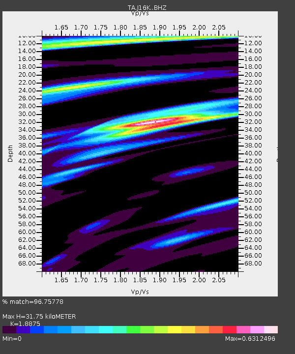
J16K Anvik River, AK, USA - Earthquake Result Viewer
| Earthquake location: |
Eastern New Guinea Reg., P.N.G. |
| Earthquake latitude/longitude: |
-7.8/147.8 |
| Earthquake time(UTC): |
2020/07/17 (199) 02:50:23 GMT |
| Earthquake Depth: |
85 km |
| Earthquake Magnitude: |
6.9 mww |
| Earthquake Catalog/Contributor: |
NEIC PDE/us |
|
| Network: |
TA USArray Transportable Network (new EarthScope stations) |
| Station: |
J16K Anvik River, AK, USA |
| Lat/Lon: |
63.28 N/160.60 W |
| Elevation: |
328 m |
|
| Distance: |
81.0 deg |
| Az: |
21.031 deg |
| Baz: |
231.874 deg |
| Ray Param: |
0.04773492 |
| Estimated Moho Depth: |
31.75 km |
| Estimated Crust Vp/Vs: |
1.89 |
| Assumed Crust Vp: |
6.276 km/s |
| Estimated Crust Vs: |
3.325 km/s |
| Estimated Crust Poisson's Ratio: |
0.30 |
|
| Radial Match: |
96.75778 % |
| Radial Bump: |
281 |
| Transverse Match: |
92.94675 % |
| Transverse Bump: |
400 |
| SOD ConfigId: |
21709731 |
| Insert Time: |
2020-07-31 03:07:40.632 +0000 |
| GWidth: |
2.5 |
| Max Bumps: |
400 |
| Tol: |
0.001 |
|

Signal To Noise
| Channel | StoN | STA | LTA |
| TA:J16K: :BHZ:20200717T03:01:57.549987Z | 71.35515 | 6.8418617E-6 | 9.588462E-8 |
| TA:J16K: :BHN:20200717T03:01:57.549987Z | 37.686516 | 1.7129001E-6 | 4.545127E-8 |
| TA:J16K: :BHE:20200717T03:01:57.549987Z | 43.31882 | 1.9139704E-6 | 4.418335E-8 |
| Arrivals |
| Ps | 4.6 SECOND |
| PpPs | 14 SECOND |
| PsPs/PpSs | 19 SECOND |


