You are here: Home > Network List > TA - USArray Transportable Network (new EarthScope stations) Stations List
> Station J30M Hart River, Yukon, CAN > Earthquake Result Viewer
J30M Hart River, Yukon, CAN - Earthquake Result Viewer
| Earthquake location: |
Eastern New Guinea Reg., P.N.G. |
| Earthquake latitude/longitude: |
-7.8/147.8 |
| Earthquake time(UTC): |
2020/07/17 (199) 02:50:23 GMT |
| Earthquake Depth: |
85 km |
| Earthquake Magnitude: |
6.9 mww |
| Earthquake Catalog/Contributor: |
NEIC PDE/us |
|
| Network: |
TA USArray Transportable Network (new EarthScope stations) |
| Station: |
J30M Hart River, Yukon, CAN |
| Lat/Lon: |
64.58 N/136.33 W |
| Elevation: |
1419 m |
|
| Distance: |
91.0 deg |
| Az: |
24.757 deg |
| Baz: |
253.973 deg |
| Ray Param: |
0.041627362 |
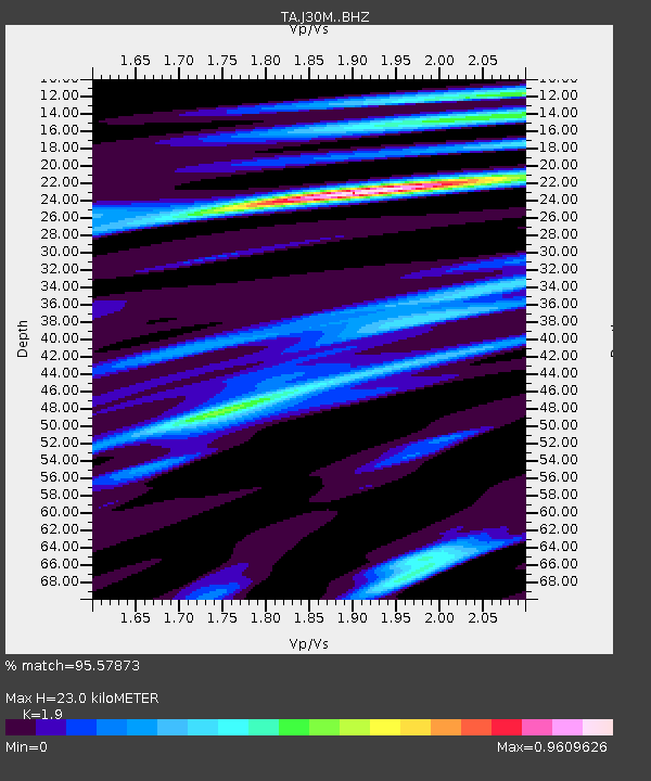
| Estimated Moho Depth: |
23.0 km |
| Estimated Crust Vp/Vs: |
1.90 |
| Assumed Crust Vp: |
6.566 km/s |
| Estimated Crust Vs: |
3.456 km/s |
| Estimated Crust Poisson's Ratio: |
0.31 |
|
| Radial Match: |
95.57873 % |
| Radial Bump: |
400 |
| Transverse Match: |
92.01895 % |
| Transverse Bump: |
400 |
| SOD ConfigId: |
21709731 |
| Insert Time: |
2020-07-31 03:07:55.645 +0000 |
| GWidth: |
2.5 |
| Max Bumps: |
400 |
| Tol: |
0.001 |
|

Signal To Noise
| Channel | StoN | STA | LTA |
| TA:J30M: :BHZ:20200717T03:02:46.999999Z | 63.643448 | 2.8917684E-6 | 4.543702E-8 |
| TA:J30M: :BHN:20200717T03:02:46.999999Z | 3.558482 | 1.3092124E-7 | 3.6791317E-8 |
| TA:J30M: :BHE:20200717T03:02:46.999999Z | 28.736727 | 9.2050766E-7 | 3.2032446E-8 |
| Arrivals |
| Ps | 3.2 SECOND |
| PpPs | 10.0 SECOND |
| PsPs/PpSs | 13 SECOND |


