You are here: Home > Network List > TA - USArray Transportable Network (new EarthScope stations) Stations List
> Station N30M Aishikik Lake, Yukon, CAN > Earthquake Result Viewer
N30M Aishikik Lake, Yukon, CAN - Earthquake Result Viewer
| Earthquake location: |
Eastern New Guinea Reg., P.N.G. |
| Earthquake latitude/longitude: |
-7.8/147.8 |
| Earthquake time(UTC): |
2020/07/17 (199) 02:50:23 GMT |
| Earthquake Depth: |
85 km |
| Earthquake Magnitude: |
6.9 mww |
| Earthquake Catalog/Contributor: |
NEIC PDE/us |
|
| Network: |
TA USArray Transportable Network (new EarthScope stations) |
| Station: |
N30M Aishikik Lake, Yukon, CAN |
| Lat/Lon: |
61.46 N/137.09 W |
| Elevation: |
941 m |
|
| Distance: |
89.8 deg |
| Az: |
27.661 deg |
| Baz: |
253.276 deg |
| Ray Param: |
0.04172393 |
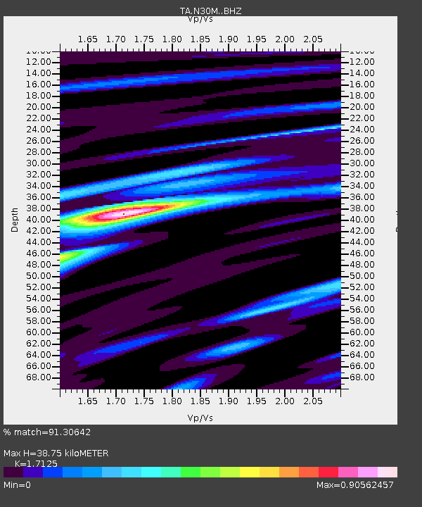
| Estimated Moho Depth: |
38.75 km |
| Estimated Crust Vp/Vs: |
1.71 |
| Assumed Crust Vp: |
6.566 km/s |
| Estimated Crust Vs: |
3.834 km/s |
| Estimated Crust Poisson's Ratio: |
0.24 |
|
| Radial Match: |
91.30642 % |
| Radial Bump: |
400 |
| Transverse Match: |
81.56021 % |
| Transverse Bump: |
400 |
| SOD ConfigId: |
21709731 |
| Insert Time: |
2020-07-31 03:08:33.042 +0000 |
| GWidth: |
2.5 |
| Max Bumps: |
400 |
| Tol: |
0.001 |
|

Signal To Noise
| Channel | StoN | STA | LTA |
| TA:N30M: :BHZ:20200717T03:02:41.400023Z | 51.16546 | 3.5003839E-6 | 6.841303E-8 |
| TA:N30M: :BHN:20200717T03:02:41.400023Z | 11.493484 | 3.4979755E-7 | 3.0434425E-8 |
| TA:N30M: :BHE:20200717T03:02:41.400023Z | 16.568415 | 1.0721966E-6 | 6.471329E-8 |
| Arrivals |
| Ps | 4.3 SECOND |
| PpPs | 16 SECOND |
| PsPs/PpSs | 20 SECOND |


