You are here: Home > Network List > UO - University of Oregon Regional Network Stations List
> Station NBFR Nehalem, OR, USA > Earthquake Result Viewer
NBFR Nehalem, OR, USA - Earthquake Result Viewer
| Earthquake location: |
Eastern New Guinea Reg., P.N.G. |
| Earthquake latitude/longitude: |
-7.8/147.8 |
| Earthquake time(UTC): |
2020/07/17 (199) 02:50:23 GMT |
| Earthquake Depth: |
85 km |
| Earthquake Magnitude: |
6.9 mww |
| Earthquake Catalog/Contributor: |
NEIC PDE/us |
|
| Network: |
UO University of Oregon Regional Network |
| Station: |
NBFR Nehalem, OR, USA |
| Lat/Lon: |
45.73 N/123.85 W |
| Elevation: |
12 m |
|
| Distance: |
94.4 deg |
| Az: |
44.613 deg |
| Baz: |
263.385 deg |
| Ray Param: |
0.04099206 |
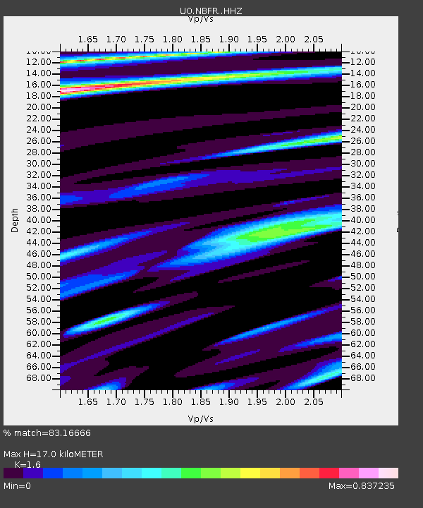
| Estimated Moho Depth: |
17.0 km |
| Estimated Crust Vp/Vs: |
1.60 |
| Assumed Crust Vp: |
6.566 km/s |
| Estimated Crust Vs: |
4.104 km/s |
| Estimated Crust Poisson's Ratio: |
0.18 |
|
| Radial Match: |
83.16666 % |
| Radial Bump: |
400 |
| Transverse Match: |
59.768936 % |
| Transverse Bump: |
400 |
| SOD ConfigId: |
21709731 |
| Insert Time: |
2020-07-31 03:09:50.606 +0000 |
| GWidth: |
2.5 |
| Max Bumps: |
400 |
| Tol: |
0.001 |
|

Signal To Noise
| Channel | StoN | STA | LTA |
| UO:NBFR: :HHZ:20200717T03:03:02.549987Z | 10.994247 | 1.8710231E-6 | 1.70182E-7 |
| UO:NBFR: :HHN:20200717T03:03:02.549987Z | 1.0846717 | 3.0417814E-7 | 2.8043337E-7 |
| UO:NBFR: :HHE:20200717T03:03:02.549987Z | 2.7761254 | 6.423739E-7 | 2.3139224E-7 |
| Arrivals |
| Ps | 1.6 SECOND |
| PpPs | 6.6 SECOND |
| PsPs/PpSs | 8.2 SECOND |


